Back مقاطعة تيزويل (إلينوي) Arabic Tazewell County, Illinois BAR Тейзуел (окръг, Илинойс) Bulgarian তাজৱেল কাউন্টি, ইলিনয়স BPY Tazewell Gông (Illinois) CDO Тазуэлл (гуо, Иллинойс) CE Tazewell County (kondado sa Tinipong Bansa, Illinois) CEB Tazewell County, Illinois Welsh Tazewell County (Illinois) German Condado de Tazewell (Illinois) Spanish
Tazewell County | |
|---|---|
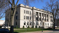
 Tazewell County Courthouse in Pekin | |
 Location within the U.S. state of Illinois | |
 Illinois's location within the U.S. | |
| Coordinates: 40°31′N 89°31′W / 40.51°N 89.51°W | |
| Country | |
| State | |
| Founded | 1827 |
| Named for | Littleton Waller Tazewell |
| Seat | Pekin |
| Largest city | Pekin |
| Area | |
| • Total | 658 sq mi (1,700 km2) |
| • Land | 649 sq mi (1,680 km2) |
| • Water | 9.0 sq mi (23 km2) 1.4% |
| Population (2020) | |
| • Total | 131,343 |
| • Density | 200/sq mi (77/km2) |
| Time zone | UTC−6 (Central) |
| • Summer (DST) | UTC−5 (CDT) |
| Congressional districts | 16th, 17th |
| Website | www |
Tazewell County (/tæzwɛl/) is located in the U.S. state of Illinois. According to the 2020 census, it had a population of 131,343.[1] Its county seat and largest city is Pekin.[2] It is pronounced with a short "a", to rhyme with "razz" rather than "raze."
Tazewell County is part of the Peoria, IL Metropolitan Statistical Area. The majority of the population lives along the county's western border.
- ^ "Tazewell County, Illinois". United States Census Bureau. Retrieved June 10, 2023.
- ^ "Find a County". National Association of Counties. Retrieved June 7, 2011.
