Back محافظة تيموتو Arabic Temotu Province CEB Temotu (Provinz) German Provincia de Temotu Spanish Temotu probintzia Basque استان تموتو Persian Temotu Finnish Province de Temotu French Temotu (Prowins) FRR Temotu Galician
This article needs additional citations for verification. (December 2011) |
Temotu Province | |
|---|---|
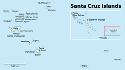
 Map of the Temotu province | |
 | |
| Coordinates: 10°45′S 167°0′E / 10.750°S 167.000°E | |
| Country | |
| Capital | Lata |
| Government | |
| • Premier | Clay Forau[1] |
| Area | |
| • Total | 895 km2 (346 sq mi) |
| Population (2009[2]) | |
| • Total | 21,362 |
| • Density | 23.9/km2 (62/sq mi) |
| Time zone | UTC+11 (+11) |
Temotu (or Te Motu, literally "the island" in Polynesian) is the easternmost province of Solomon Islands. The province was formerly known as Santa Cruz Islands Province. It consists, essentially, of two chains of islands which run parallel to each other from the northwest to the southeast. Its area is 895 square kilometres (346 square miles).
- ^ "Solomon Islands Provinces".
- ^ Report on 2009 population & housing census for the Solomon Islands.
