| Tualatin River National Wildlife Refuge | |
|---|---|
IUCN category IV (habitat/species management area) | |
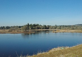
 Pond at the park with woodlands in background | |
| Location | Washington and Yamhill counties Oregon, United States |
| Nearest city | Sherwood, Oregon |
| Coordinates | 45°23′20″N 122°51′30″W / 45.38889°N 122.85833°W |
| Area | 1,856 acres (751 ha)[1] |
| Established | 1992 Opened in 2006 |
| Visitors | 150,000+ (in 2020) |
| Governing body | U.S. Fish and Wildlife Service |
| Website | www |
The Tualatin River National Wildlife Refuge is a 1,856 acres (751 ha) wetlands and lowlands sanctuary in the northwestern part of the U.S. state of Oregon. Established in 1992 and opened to the public in 2006, it is managed by the United States Fish and Wildlife Service. Located in southeastern Washington County, 15 miles (24 km) southwest of Portland, the refuge is bordered by Sherwood, Tualatin and Tigard. A newer area, extending into northern Yamhill County, is located further west near the city of Gaston surrounding the former Wapato Lake.
Part of the network of National Wildlife Refuges (NWR), the Tualatin River refuge is one of only ten urban refuges in the United States. Habitats in the refuge include forested areas, wetlands, oak and pine grassland, and meadows, with mixed deciduous and coniferous forests common to Western Oregon. The refuge was established as an urban refuge to provide wetland, riparian, and upland habitats for a variety of migratory birds, threatened and endangered species, fish and other resident wildlife. The refuge is home to nearly 200 bird species and more than 70 other animal species.
A visitor center with exhibits and information about the refuge was opened in 2008 off of Oregon Route 99W near Sherwood in the Portland metropolitan area. Next to the center is the refuge's headquarters and an observation deck overlooking seasonal ponds. The refuge has nearly five miles of wildlife interpretive trails open to the public. Up to 50,000 waterfowl can be seen at the refuge during the winter months when officials flood portions of the refuge.
