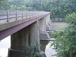
Turners Falls Road Bridge | |
|---|---|
 Upstream side of the bridge with the river fully diverted away | |
| Coordinates | 42°36′33″N 72°33′41″W / 42.60917°N 72.56139°W |
| Carries | vehicular and pedestrian traffic |
| Crosses | Connecticut River |
| Locale | Greenfield and Montague, Franklin County, Massachusetts |
| Official name | White Bridge |
| Maintained by | MassHighway |
| ID number | G1200212RMHDNBI |
| Characteristics | |
| Design | Stringer/Multi-beam or Girder |
| Material | Steel (and concrete) |
| Total length | 135.9 metres (445.9 ft) |
| Width | 6.1 metres (20.0 ft) |
| No. of spans | 6 |
| Piers in water | 5 |
| Load limit | 51.5 metric tons |
| History | |
| Opened | 1936 |
| Statistics | |
| Daily traffic | 10,800 (2003) |
| Location | |
 | |
The Turners Falls Road Bridge (officially White Bridge) is a concrete and steel road bridge over the Connecticut River in the U.S. state of Massachusetts. It carries Turners Falls Road and connects the town center of Greenfield and the village of Turners Falls (in the town of Montague).
