Back ایستگاه راهآهن آپر هالووی Persian Upper Hollowayn rautatieasema Finnish Stazione di Upper Holloway Italian Stazion de Upper Holloway LMO Station Upper Holloway Dutch Upper Holloway stasjon NB Аппер-Голловей (станція) Ukrainian اپر ہولوے ریلوے اسٹیشن Urdu אפער האלאוויי באן סטאנציע YI 上霍洛威站 Chinese
| Upper Holloway | |
|---|---|
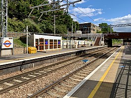
 The station in 2020 | |
| Location | Upper Holloway |
| Local authority | London Borough of Islington |
| Managed by | London Overground |
| Owner | Network Rail |
| Station code | UHL |
| DfT category | E |
| Number of platforms | 2 |
| Accessible | Yes[1] |
| Fare zone | 2 |
| OSI | Archway |
| National Rail annual entry and exit | |
| 2018–19 | |
| 2019–20 | |
| 2020–21 | |
| 2021–22 | |
| 2022–23 | |
| Key dates | |
| 1868 | Opened |
| Other information | |
| External links | |
| Coordinates | 51°33′50″N 0°07′47″W / 51.5638°N 0.1298°W |
Upper Holloway railway station is in Holloway, north London (N19). It is on the Gospel Oak to Barking line, 3 miles 0 chains (4.8 km) from St Pancras (measured via Kentish Town and Mortimer Street Junction)[4] and is situated between Gospel Oak and Crouch Hill. It is operated by London Overground, and the service is one train every 15 minutes in each direction except late evenings when it is half-hourly. The line is now electrified, and services are operated by 4 car Class 710 EMUs.
The station is a short walk along Holloway Road from Archway on the Northern line. This is currently the most convenient interchange between the two lines, given as 490 yards (450 m) on the tube map and maps inside London Overground trains.
London Overground | |||||||||||||||||||||||||||||||||||||||||||||||||||||||||||||||||||||||||||||||||||||||||||||||||||||||||||||||||||||||||||||||||||||||||||||||||||||||||||||||||||||||||||||||||||||||||||||||||||||||||||||||||||||||||||||||||||||||||||||||||||||||||||||||||||||||||||||||||||||||||||||||||||||||||||||||||||||||||||
|---|---|---|---|---|---|---|---|---|---|---|---|---|---|---|---|---|---|---|---|---|---|---|---|---|---|---|---|---|---|---|---|---|---|---|---|---|---|---|---|---|---|---|---|---|---|---|---|---|---|---|---|---|---|---|---|---|---|---|---|---|---|---|---|---|---|---|---|---|---|---|---|---|---|---|---|---|---|---|---|---|---|---|---|---|---|---|---|---|---|---|---|---|---|---|---|---|---|---|---|---|---|---|---|---|---|---|---|---|---|---|---|---|---|---|---|---|---|---|---|---|---|---|---|---|---|---|---|---|---|---|---|---|---|---|---|---|---|---|---|---|---|---|---|---|---|---|---|---|---|---|---|---|---|---|---|---|---|---|---|---|---|---|---|---|---|---|---|---|---|---|---|---|---|---|---|---|---|---|---|---|---|---|---|---|---|---|---|---|---|---|---|---|---|---|---|---|---|---|---|---|---|---|---|---|---|---|---|---|---|---|---|---|---|---|---|---|---|---|---|---|---|---|---|---|---|---|---|---|---|---|---|---|---|---|---|---|---|---|---|---|---|---|---|---|---|---|---|---|---|---|---|---|---|---|---|---|---|---|---|---|---|---|---|---|---|---|---|---|---|---|---|---|---|---|---|---|---|---|---|---|---|---|---|---|---|---|---|---|---|---|---|---|---|---|---|---|---|---|---|---|---|---|---|---|---|---|---|---|---|---|---|---|---|---|---|
| |||||||||||||||||||||||||||||||||||||||||||||||||||||||||||||||||||||||||||||||||||||||||||||||||||||||||||||||||||||||||||||||||||||||||||||||||||||||||||||||||||||||||||||||||||||||||||||||||||||||||||||||||||||||||||||||||||||||||||||||||||||||||||||||||||||||||||||||||||||||||||||||||||||||||||||||||||||||||||
Legend
| |||||||||||||||||||||||||||||||||||||||||||||||||||||||||||||||||||||||||||||||||||||||||||||||||||||||||||||||||||||||||||||||||||||||||||||||||||||||||||||||||||||||||||||||||||||||||||||||||||||||||||||||||||||||||||||||||||||||||||||||||||||||||||||||||||||||||||||||||||||||||||||||||||||||||||||||||||||||||||
| |||||||||||||||||||||||||||||||||||||||||||||||||||||||||||||||||||||||||||||||||||||||||||||||||||||||||||||||||||||||||||||||||||||||||||||||||||||||||||||||||||||||||||||||||||||||||||||||||||||||||||||||||||||||||||||||||||||||||||||||||||||||||||||||||||||||||||||||||||||||||||||||||||||||||||||||||||||||||||
- ^ "London and South East" (PDF). National Rail. September 2006. Archived from the original (PDF) on 6 March 2009.
- ^ "Out-of-Station Interchanges" (Microsoft Excel). Transport for London. 2 January 2016. Retrieved 28 August 2016.
- ^ a b c d e "Estimates of station usage". Rail statistics. Office of Rail Regulation. Please note: Some methodology may vary year on year.
- ^ Yonge, John; Padgett, David; Szwenk, John (August 2013) [1990]. Bridge, Mike (ed.). Railway Track Diagrams 4: Midlands & North West (3rd ed.). Bradford on Avon: Trackmaps. map 1R. ISBN 978-0-9549866-7-4.
