Back مقاطعة واشنطن (فيرمونت) Arabic واشينطون كاونتى (ڤيرمونت) ARZ Condáu de Washington (Vermont) AST Washington County, Vermont BAR Вашингтон (окръг, Вермонт) Bulgarian ৱাশিংটন কাউন্টি, ভার্মন্ট BPY Washington Gông (Vermont) CDO Вашингтон (гуо, Вермонт) CE Washington County (kondado sa Tinipong Bansa, Vermont) CEB Washington County, Vermont Welsh
Washington County | |
|---|---|
 Washington County Courthouse | |
 Location within the U.S. state of Vermont | |
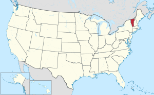
 Vermont's location within the U.S. | |
| Coordinates: 44°14′57″N 72°34′51″W / 44.249287°N 72.580894°W | |
| Country | |
| State | |
| Founded | 1811 |
| Named for | George Washington |
| Shire Town | Montpelier |
| Largest city | Barre |
| Area | |
| • Total | 695 sq mi (1,800 km2) |
| • Land | 687 sq mi (1,780 km2) |
| • Water | 8.2 sq mi (21 km2) 1.2% |
| Population (2020) | |
| • Total | 59,807 |
| • Density | 86/sq mi (33/km2) |
| Time zone | UTC−5 (Eastern) |
| • Summer (DST) | UTC−4 (EDT) |
| Congressional district | At-large |
Washington County is a county located in the U.S. state of Vermont. Named after George Washington, its shire town (county seat) is the city of Montpelier (the least populous state capital in the United States) and the most populous municipality is the city of Barre.[1] As of the 2020 census, the population was 59,807,[2] making it the third-most populous county in Vermont, but the third-least populous capital county in the United States after Hughes County, South Dakota and Franklin County, Kentucky. Washington County comprises the Barre, Vermont micropolitan statistical area. In 2010, the center of population of Vermont was located in Washington County, in the town of Warren.[3]
- ^ "Find a County". National Association of Counties. Retrieved June 7, 2011.
- ^ "State & County QuickFacts". United States Census Bureau. Retrieved October 28, 2021.
- ^ "Centers of Population by State: 2010". United States Census Bureau. Retrieved May 6, 2014.