Back مدينه يارا ARZ Yara (Kuba) German Yara Spanish یارا (کوبا) Persian Yara (Cuba) French יארה HE Yara (Cuba) Italian იარა (კუბა) Georgian Yara (Cuba) Dutch Яра Ukrainian
Yara | |
|---|---|
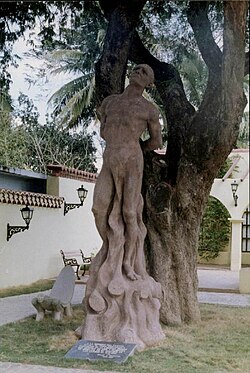
 Monument of Taino chief Hatuey in Yara, depicting the moment he was burnt by Spanish soldiers. Bind to a tamarind tree planted in 1907. | |
 Yara municipality (red) within Granma Province (yellow) and Cuba | |
| Coordinates: 20°16′36″N 76°56′49″W / 20.27667°N 76.94694°W | |
| Country | Cuba |
| Province | Granma |
| Established | 1912 |
| Area | |
| • Total | 576 km2 (222 sq mi) |
| Elevation | 30 m (100 ft) |
| Population (2022)[2] | |
| • Total | 53,818 |
| • Density | 93/km2 (240/sq mi) |
| Time zone | UTC-5 (EST) |
| Area code | +53-23 |
| Website | https://www.yara.gob.cu/ |
Yara is a small town and municipality in the Granma Province of Cuba, located halfway between the cities of Bayamo and Manzanillo, in the Gulf of Guacanayabo. Yara means "place" in the Taíno language.[3]
