Back إعصار متوسط الشمول Arabic Mesocicló Catalan Mesocyklon Danish Mesozyklone German Μεσοκυκλώνας Greek Mesociclón Spanish Mesozikloi Basque میانچرخند Persian Mesosykloni Finnish Mésocyclone French

| Part of a series on |
| Weather |
|---|
|
|
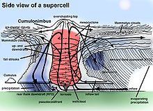
A mesocyclone is a meso-gamma mesoscale (or storm scale) region of rotation (vortex), typically around 2 to 6 mi (3.2 to 9.7 km) in diameter, most often noticed on radar within thunderstorms. In the northern hemisphere it is usually located in the right rear flank (back edge with respect to direction of movement) of a supercell, or often on the eastern, or leading, flank of a high-precipitation variety of supercell. The area overlaid by a mesocyclone’s circulation may be several miles (km) wide, but substantially larger than any tornado that may develop within it, and it is within mesocyclones that intense tornadoes form.[1]