Back Uttar Pradesh ACE Uttar Pradesh Afrikaans ኡተር ፕረዴሽ Amharic उत्तर प्रदेश ANP أتر برديش Arabic উত্তৰ প্ৰদেশ Assamese Uttar Pradesh AST उत्तर प्रदेश AWA Uttar-Pradeş Azerbaijani اوتار پرادش AZB
Uttar Pradesh (/ˌʊtər prəˈdɛʃ/;[13] lit. 'North Province') is a state in northern India. With over 241 million inhabitants, it is the most populated state in India as well as the most populous country subdivision in the world – more populous than all but four other countries outside of India[14] – and accounting for 16.5 per cent of the total population of India. The state is bordered by Rajasthan to the west, Haryana, Himachal Pradesh and Delhi to the northwest, Uttarakhand and Nepal to the north, Bihar to the east, Madhya Pradesh, Chhattisgarh and Jharkhand to the south. It is the fourth-largest Indian state by area covering 243,286 km2 (93,933 sq mi), equal to 7.3 per cent of the total area of India. Lucknow serves as the state capital, with Prayagraj being the judicial capital. It is divided into 18 divisions and 75 districts. On 9 November 2000, a new state, Uttaranchal (now Uttarakhand), was created from Uttar Pradesh's western Himalayan hill region. The two major rivers of the state, the Ganges and its tributary Yamuna, meet at the Triveni Sangam in Prayagraj, a Hindu pilgrimage site. Other notable rivers are Gomti and Saryu. The forest cover in the state is 6.1 per cent of the state's geographical area. The cultivable area is 82 per cent of the total geographical area, and the net area sown is 68.5 per cent of the cultivable area.[15]
Uttar Pradesh was established in 1950 after India had become a republic. It is a successor to the United Provinces, established in 1935 by renaming the United Provinces of Agra and Oudh, in turn established in 1902 from the North-Western Provinces and the Oudh Province. Though long known for sugar production, the state's economy is now dominated by the services industry. The service sector comprises travel and tourism, hotel industry, real estate, insurance and financial consultancies. The economy of Uttar Pradesh is the third-largest state economy in India, with ₹18.63 lakh crore (US$230 billion) in gross domestic product and a per capita GSDP of ₹68,810 (US$860).[9] The High Court of the state is located in Prayagraj. The state contributes 80 seats and 31 seats to the lower house Lok Sabha and the upper house Rajya Sabha, respectively.
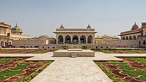
Inhabitants of the state are called Awadhi, Bagheli, Bhojpuriya, Braji, Bundeli, Kannauji or Rohilkhandi depending upon their region of origin. Hinduism is practised by more than three-fourths of the population, with Islam being the next-largest religious group. Hindi is the most widely spoken language and is also the official language of the state, along with Urdu. Uttar Pradesh was home to most of the mainstream political entities that existed in ancient and medieval India including the Maurya Empire, Harsha Empire, Gupta Empire, Pala Empire, Delhi Sultanate and Mughal Empire as well as many other empires. At the time of the Indian independence movement in the early 20th century, there were three major princely states in Uttar Pradesh – Ramgadi, Rampur and Benares. The state houses several holy Hindu temples and pilgrimage centres. Along with several historical, natural and religious tourist destinations, including Agra, Aligarh, Ayodhya, Bareilly, Gorakhpur, Kanpur, Kushinagar, Lucknow, Mathura, Meerut, Prayagraj, Varanasi, and Vrindavan, Uttar Pradesh is also home to three World Heritage sites.
- ^ "United Province, UP was notified in Union gazette on January 24, 1950". The New Indian Express. 2 May 2017. Archived from the original on 8 May 2017. Retrieved 4 May 2017.
- ^ "Uttar Pradesh District". up.gov.in. Government of Uttar Pradesh. Archived from the original on 15 April 2017. Retrieved 12 April 2017.
- ^ "List of districts in Uttar Pradesh". archive.india.gov.in. Government of India. Archived from the original on 26 April 2017. Retrieved 12 April 2017.
- ^ PTI (20 July 2019). "Anandiben Patel made UP governor, Lal ji Tandon to replace her in Madhya Pradesh". India Today. Archived from the original on 20 July 2019. Retrieved 20 July 2019.
- ^ "The Governor of Uttar Pradesh". uplegisassembly.gov.in. Uttar Pradesh Legislative Assembly. Archived from the original on 3 May 2017. Retrieved 12 April 2017.
- ^ "Uttar Pradesh | History, Government, Map, & Population | Britannica". Encyclopedia Britannica. Archived from the original on 1 April 2020. Retrieved 24 March 2023.
- ^ "List of Highest Mountain Peaks State-wise". Wordpandit. 29 July 2017. Archived from the original on 24 March 2023. Retrieved 24 March 2023.
- ^ Cite error: The named reference
2011langwas invoked but never defined (see the help page). - ^ a b "Handbook of Statistics of Indian States 2021–22" (PDF). Reserve Bank of India. pp. 37–42. Archived (PDF) from the original on 29 January 2022. Retrieved 11 February 2022.
- ^ "Sub-national HDI – Area Database". Global Data Lab. Institute for Management Research, Radboud University. Archived from the original on 23 September 2018. Retrieved 25 September 2018.
- ^ "Census 2011 (Final Data) – Demographic details, Literate Population (Total, Rural & Urban)" (PDF). planningcommission.gov.in. Planning Commission, Government of India. Archived from the original (PDF) on 27 January 2018. Retrieved 3 October 2018.
- ^ "Sex ratio of State and Union Territories of India as per National Health survey (2019–2021)". Ministry of Health and Family Welfare, India. Archived from the original on 8 January 2023. Retrieved 8 January 2023.
- ^ "Uttar Pradesh". Lexico UK English Dictionary. Oxford University Press. Archived from the original on 26 April 2022.
- ^ Kopf, Dan; Varathan, Preeti (11 October 2017). "If Uttar Pradesh were a country". Quartz India. Archived from the original on 22 June 2019. Retrieved 20 May 2019.
- ^ "Agriculture" (PDF). niti.gov.in. NITI Aayog. Archived (PDF) from the original on 7 October 2021. Retrieved 19 October 2021.


