Back درجات حرارة جوية Arabic Температура на въздуха Bulgarian Temperatura atmosférica Spanish Suhu atmosfir ID Atmospheric temperature IG 気温 Japanese 기온 Korean Temperatur (meteorologi) NB Temperatura atmosférica Portuguese Hava sıcaklığı Turkish

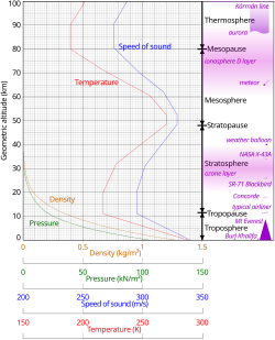
Atmospheric temperature is a measure of temperature at different levels of the Earth's atmosphere. It is governed by many factors, including incoming solar radiation, humidity, and altitude. The abbreviation MAAT is often used for Mean Annual Air Temperature of a geographical location.

- ^ Geometric altitude vs. temperature, pressure, density, and the speed of sound derived from the 1962 U.S. Standard Atmosphere.
- ^ Karger, D.N.; Conrad, O.; Böhner, J.; Kawohl, T.; Kreft, H.; Soria-Auza, R.W.; Zimmermann, N.E.; Linder, P.; Kessler, M. (2017). "Climatologies at high resolution for the Earth land surface areas". Scientific Data. 4 (4 170122): 170122. Bibcode:2017NatSD...470122K. doi:10.1038/sdata.2017.122. PMC 5584396. PMID 28872642.