Back Cleveland (sir) Welsh Cleveland (hrabstwo) Polish Кливленд (графство) Russian Cleveland, England SIMPLE Cleveland, England Swedish
| Cleveland | |
|---|---|
 | |
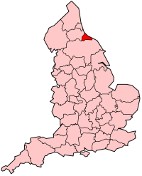
 The former administrative county of Cleveland shown within England | |
| Area | |
| • 1974 | 144,085 acres (583.09 km2)[1] |
| Population | |
| • 1973 | 566,740[2] |
| • 1981 | 565,935 |
| • 1991 | 541,333 |
| History | |
| • Origin | County Borough of Teesside |
| • Created | 1974 |
| • Abolished | 1996 |
| ONS code | 14 |
| Government | Cleveland County Council |
| • Type | Two-tier - upper-tier county council with four lower-tier non-metropolitan borough councils |
| • HQ | Middlesbrough |
| Subdivisions | |
| • Type | Non-metropolitan districts |
| • Units | |
 | |
| Today part of | North Yorkshire and County Durham |
Cleveland was a non-metropolitan county located in North East England which existed between 1974 and 1996. Cleveland was a two-tier county and had four boroughs: Hartlepool, Stockton-on-Tees, Middlesbrough and Langbaurgh-on-Tees. The county town was Middlesbrough, where Cleveland County Council met. The county was named after the historic area of Cleveland, Yorkshire. Its area is now split between the counties of North Yorkshire and County Durham.
The county was abolished in 1996, with its constituent boroughs becoming unitary authorities. Hartlepool and the part of Stockton-on-Tees north of the River Tees became part of the County Durham, and the remainder became part of North Yorkshire. Some public bodies continue to cover the area of the former county, such as Cleveland Police and Cleveland Fire Brigade. Cleveland bordered County Durham to the north and North Yorkshire to the south, with a coastline on the North Sea to the east. It had a total area of 225 square miles (583 km2).

- ^ Local government in England and Wales: A Guide to the New System. London: HMSO. 1974. p. 37. ISBN 0-11-750847-0.
- ^ Registrar General's annual estimated figure mid 1973

