Back سهل الغانج الهندي Arabic Llanura indoganxética AST Hind-Qanq ovalığı Azerbaijani Һинд-Ганг тигеҙлеге Bashkir Інда-Гангская раўніна Byelorussian Индо-Гангска равнина Bulgarian सिंधु-गंगा के मैदान Bihari সিন্ধু-গাঙ্গেয় সমভূমি Bengali/Bangla Plana Indogangètica Catalan Indo-Gangetic Plain CEB
This article needs additional citations for verification. (January 2016) |


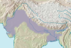
The Indo-Gangetic Plain, also known as the North Indian River Plain, is a 700-thousand km2 (172-million-acre) fertile plain encompassing northern regions of the Indian subcontinent, including most of modern-day northern and eastern India, most of eastern-Pakistan, virtually all of Bangladesh and southern plains of Nepal.[1] Also known as the Indus–Ganga Plain, the region is named after the Indus and the Ganges rivers and encompasses a number of large urban areas. The plain is bounded on the north by the Himalayas, which feed its numerous rivers and are the source of the fertile alluvium deposited across the region by the two river systems. The southern edge of the plain is marked by the Deccan Plateau. On the west rises the Iranian Plateau. Many developed cities like Delhi, Dhaka, Kolkata, Lahore, Islamabad and Karachi are located in the Indo-Gangetic Plain.
- ^ Taneja, Garima; Pal, Barun Deb; Joshi, Pramod Kumar; Aggarwal, Pramod K.; Tyagi, N. K. (2014). Farmers preferences for climate-smart agriculture: An assessment in the Indo-Gangetic Plain. Intl Food Policy Res Inst. p. 2.