Back Manila Trench CEB Fosse de Manille French Palung Manila ID Fossa di Manila Italian マニラ海溝 Japanese Манильский жёлоб Russian Rãnh Manila Vietnamese 馬尼拉海溝 Chinese

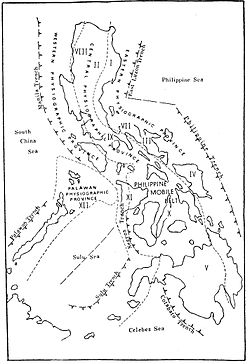
The Manila Trench is an oceanic trench in the Pacific Ocean, located west of the islands of Luzon and Mindoro in the Philippines. The trench reaches a depth of about 5,400 metres (17,700 ft),[8] in contrast with the average depth of the South China Sea of about 1,500 metres (4,900 ft). It is created by subduction, in which the Sunda Plate (part of Eurasian Plate) is subducting under the Philippine Mobile Belt, producing this almost N-S trending trench. The convergent boundary is terminated to the north by the Taiwan collision zone, and to the south by the Mindoro terrane (Sulu-Palawan block colliding with SW Luzon). It is an area pervaded by negative gravity anomalies.[9]
The Manila Trench is associated with frequent earthquakes, and the subduction zone is responsible for the belt of volcanoes on the west side of the Philippine island of Luzon, which includes Mount Pinatubo.
Convergence between the Philippine Mobile Belt and the Sunda Plate have been estimated using GPS measurements, and this value ranges from ~ 50+ mm/yr in Taiwan, to 100 mm/yr near N. Luzon, and ~ 50 mm/yr near Zambales and ~20+mm/yr near Mindoro island.[10] Plate locking between the Sunda Plate and Luzon is about 1% coupled, almost unlocked as determined by elastic block models, suggesting that the trench absorbs the Philippine Mobile Belt-Eurasian Plate convergence.[11][clarification needed]
- ^ "M 6.7 - Luzon, Philippines". United States Geological Survey. Retrieved March 15, 2018.
- ^ "M 7.5 - Philippine Islands region". United States Geological Survey. Retrieved March 15, 2018.
- ^ "M 7.4 - Mindoro, Philippines". United States Geological Survey. Retrieved March 15, 2018.
- ^ "M 6.4 - Philippine Islands region". United States Geological Survey. Retrieved March 15, 2018.
- ^ "M 6.7 - Philippine Islands region". United States Geological Survey. Retrieved March 15, 2018.
- ^ "M 7.5 - Mindoro, Philippines". United States Geological Survey. Retrieved March 15, 2018.
- ^ "M 7.3 - Luzon, Philippines". United States Geological Survey. Retrieved April 22, 2019.
- ^ Liu et al. 2007
- ^ Bowin et al. 1978; Hayes & Lewis 1984
- ^ Rangin et al. 1999; Galgana et al. 2007
- ^ Kreemer & Holt 2001; Galgana et al. 2007
