Back Laôt Okhotsk ACE See van Ochotsk Afrikaans بحر أوخوتسك Arabic بحر ؤخوتسك ARY Mar d'Ojotsk AST Oxotsk Bira AVK Oxot dənizi Azerbaijani اوخوتسک دنیزی AZB Охот диңгеҙе Bashkir Ochuotska jūra BAT-SMG
| Sea of Okhotsk | |
|---|---|
 Sea of Okhotsk | |
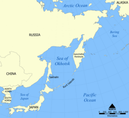
 Map of the Sea of Okhotsk | |
| Location | North Asia and East Asia |
| Coordinates | 55°N 150°E / 55°N 150°E |
| Type | Sea |
| Basin countries | Japan and Russia |
| Surface area | 1,583,000 km2 (611,200 sq mi) |
| Average depth | 859 m (2,818 ft) |
| Max. depth | 3,372 m (11,063 ft) |
The Sea of Okhotsk[a] is a marginal sea of the western Pacific Ocean.[1] It is located between Russia's Kamchatka Peninsula on the east, the Kuril Islands on the southeast, Japan's island of Hokkaido on the south, the island of Sakhalin along the west, and a stretch of eastern Siberian coast along the west and north. The northeast corner is the Shelikhov Gulf. The sea is named for the port of Okhotsk, itself named for the Okhota River.[2]
Cite error: There are <ref group=lower-alpha> tags or {{efn}} templates on this page, but the references will not show without a {{reflist|group=lower-alpha}} template or {{notelist}} template (see the help page).
- ^ Kon-Kee Liu; Larry Atkinson (June 2009). Carbon and Nutrient Fluxes in Continental Margins: A Global Synthesis. Springer. pp. 331–333. ISBN 978-3-540-92734-1. Retrieved 29 November 2010.
- ^ Everett-Heath, John (2020). "Okhotsk, Sea of (Okhotskoye More)". Concise Oxford Dictionary of World Place Names (6th ed.). Oxford University Press. ISBN 9780191905636.