Back Tauranga Afrikaans تاورانجا Arabic تاورانجا ARZ Tauranga AST Tauranqa (Yeni Zellandiya) Azerbaijani Таўранга Byelorussian Тауранга Bulgarian Tauranga Catalan Tauranga (kapital sa distrito) CEB Tauranga Czech
Tauranga | |
|---|---|
| Coordinates: 37°41′S 176°10′E / 37.683°S 176.167°E | |
| Country | New Zealand |
| Island | North Island |
| Region | Bay of Plenty |
| Wards | Mount Maunganui-Papamoa Otumoetai-Pyes Pa Te Papa-Welcome Bay |
| Settled | 1250–1300 |
| Gazetted as a borough | 1882 |
| City constituted | 17 April 1963 |
| Electorate(s) | Tauranga Bay of Plenty |
| Government | |
| • MP (Tauranga) | Sam Uffindell (New Zealand National Party) |
| • MP (Bay of Plenty) | Tom Rutherford (New Zealand National Party) |
| • Mayor | n/a |
| • Deputy Mayor | Tina Salisbury |
| • Territorial authority | Tauranga City Council |
| Area | |
| • Land | 141.91 km2 (54.79 sq mi) |
| Highest elevation | 232 m (761 ft) |
| Lowest elevation | 0 m (0 ft) |
| Population (June 2023)[2] | |
| • Territorial | 161,800 |
| • Urban | 161,800 |
| Time zone | UTC+12:00 (NZST) |
| • Summer (DST) | UTC+13:00 (NZDT) |
| Postcode(s) | 3110, 3112, 3116, 3118 |
| Area code | 07 |
| Local iwi | Ngāti Ranginui, Ngāi Te Rangi, Ngāti Pūkenga |
| Website | Tauranga.govt.nz |
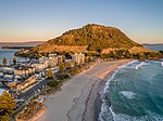
Tauranga (Māori pronunciation: [ˈtaʉɾaŋa])[3][4] is a coastal city in the Bay of Plenty Region and the fifth-most populous city of New Zealand, with an urban population of 161,800 (June 2023)[2], or roughly 3% of the national population. It was settled by Māori late in the 13th century, colonised by Europeans in the early 19th century, and was constituted as a city in 1963.[5]
The city lies in the north-western corner of the Bay of Plenty, on the south-eastern edge of Tauranga Harbour. The city extends over an area of 141.91 square kilometres (54.79 sq mi), and encompasses the communities of Bethlehem, on the south-western outskirts of the city; Greerton, on the southern outskirts of the city; Matua, west of the central city overlooking Tauranga Harbour; Maungatapu; Mount Maunganui, located north of the central city across the harbour facing the Bay of Plenty; Otūmoetai; Papamoa, Tauranga's largest suburb, located in the Bay of Plenty; Tauranga City; Tauranga South; and Welcome Bay.
Tauranga is one of New Zealand's main centres for business, international trade, culture, fashion and horticultural science. The Port of Tauranga is New Zealand's largest port in terms of gross export tonnage and efficiency.[6] Tauranga is one of New Zealand's fastest-growing cities, with an 11% increase in population between the 2006 census and the 2013 census,[7] and 19% between the 2013 and 2018 census. Due to its rapid population growth, Tauranga has become New Zealand's fifth-largest city, overtaking Dunedin and the Napier-Hastings urban areas.
- ^ Cite error: The named reference
Areawas invoked but never defined (see the help page). - ^ a b "Subnational population estimates (RC, SA2), by age and sex, at 30 June 1996-2023 (2023 boundaries)". Statistics New Zealand. Retrieved 25 October 2023. (regional councils); "Subnational population estimates (TA, SA2), by age and sex, at 30 June 1996-2023 (2023 boundaries)". Statistics New Zealand. Retrieved 25 October 2023. (territorial authorities); "Subnational population estimates (urban rural), by age and sex, at 30 June 1996-2023 (2023 boundaries)". Statistics New Zealand. Retrieved 25 October 2023. (urban areas)
- ^ "100 Māori words every New Zealander should know – Māori Language Week | NZHistory, New Zealand history online". Nzhistory.net.nz. 1 August 1987. Archived from the original on 1 August 2012. Retrieved 20 September 2015.
- ^ "Tauranga pronunciation: How to pronounce Tauranga in Māori, English". Forvo.com. 12 April 2008. Archived from the original on 11 September 2015. Retrieved 20 September 2015.
- ^ "Local Government 1860 – present". Tauranga City Council. Archived from the original on 14 October 2008. Retrieved 19 December 2008.
- ^ "Port of Tauranga Limited – New Zealand's largest and most efficient port – Port of Tauranga". Port-tauranga.co.nz. Archived from the original on 15 September 2015. Retrieved 20 September 2015.
- ^ "Auckland drives 5% population growth | Radio New Zealand News". Radionz.co.nz. 15 October 2013. Archived from the original on 24 September 2015. Retrieved 20 September 2015.


