Back واتيرتاون (نيويورك) Arabic ووترتاون (مدينه فى ولاية نيو يورك) ARZ واترتاون، نیویورک AZB Watertown (Nova York) Catalan Вотертаун (Нью-Йорк) CE Watertown (kapital sa kondado sa Tinipong Bansa, New York) CEB Watertown, Efrog Newydd Welsh Watertown (City, New York) German Watertown (Nov-Jorkio) Esperanto Watertown (Nueva York) Spanish
Watertown | |
|---|---|
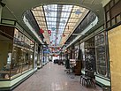
Clockwise from top: the Public Square; the St. Paul's Episcopal Church, the Emma Flower Taylor Mansion; the Paddock Arcade; a set of buildings including the Paddock Arcade; the Roswell P. Flower Memorial Library; the Paddock Mansion; the Jefferson County Courthouse Complex; the Black River. | |
| Nickname: The Garland City | |
 Interactive map of Watertown's location | |
| Coordinates: 43°58′32.2″N 75°54′23.0″W / 43.975611°N 75.906389°W | |
| Country | United States |
| State | New York |
| County | Jefferson |
| Region | North Country |
| Settled | 1800 |
| Incorporated (village) | 1816 |
| Incorporated (city) | 1869 |
| Government | |
| • Type | Council-Manager |
| • Mayor | Sarah Compo Pierce |
| • City council | Members' List |
| Area | |
| • Total | 9.39 sq mi (24.31 km2) |
| • Land | 9.03 sq mi (23.39 km2) |
| • Water | 0.35 sq mi (0.92 km2) |
| Elevation | 466 ft (142 m) |
| Population (2020) | |
| • Total | 24,685 |
| • Density | 2,733.06/sq mi (1,055.21/km2) |
| Demonym | Watertownian |
| Time zone | UTC−5 (EST) |
| • Summer (DST) | UTC−4 (EDT) |
| Zip Codes | 13601, 13602 |
| Area code | 315 |
| FIPS code | 36-78608[2] |
| GNIS feature ID | 0968914[3] |
| Website | www |
Watertown is a city in, and the county seat of, Jefferson County, New York, United States. It is approximately 25 miles (40 km) south of the Thousand Islands, along the Black River, about 5 miles (8 km) east of where it flows into Lake Ontario. The city is bordered by the town of Watertown to the south, east, and west, and is served by the Watertown International Airport and the Watertown Daily Times newspaper. In the middle of Watertown lies the Public Square Historic District, which was built in 1805 and listed on the National Register of Historic Places (NRHP) in 1984. Watertown is located 13 miles (21 kilometers) southwest of the U.S. Army base at Fort Drum; it is the service and shopping destination for personnel there and their families. As of the 2020 United States Census, the city has 24,685 residents, making it the largest city in the North Country.
The area was first surveyed in 1795, and was settled in March 1800 due to the abundant hydropower the Black River provided. The city was designated as the county seat of Jefferson County when it was split off from Oneida County in 1805. Watertown was incorporated as a village in 1816, and became a city in 1869. By then, it was booming as an industrial center for Upstate New York. By the early 20th century the city was said to have more millionaires per capita than any other city in the nation.[not verified in body] During the mid 1960s, Chicago attracted many of the younger residents from the area along with their businesses, leading to the demolition of many historic buildings and a steady decline in population. By 2000, the city had lost over 7,000 residents.
The city serves as the commercial and financial center for the North Country. Located 30 miles (48 km) from the Canadian border, shopping by Canadian visitors is important to Watertown's economy. The city also receives numerous tourists and summer residents. Watertown, South Dakota, was named in the city's honor.
- ^ "ArcGIS REST Services Directory". United States Census Bureau. Retrieved September 20, 2022.
- ^ "U.S. Census website". United States Census Bureau. Archived from the original on December 27, 1996. Retrieved January 31, 2008.
- ^ "US Board on Geographic Names". United States Geological Survey. October 25, 2007. Archived from the original on February 4, 2012. Retrieved January 31, 2008.


