Back أثينا (جورجيا) Arabic اثينا (كلارك, ولايه جورجيا) ARZ آتن، جورجیا AZB Атэнс (Джорджыя) Byelorussian Атънс Bulgarian Athens (Georgia) Breton Athens (Geòrgia) Catalan Атенс (Джорджи) CE Athens (kapital sa kondado sa Tinipong Bansa, Georgia) CEB ئەتینا، جۆرجیا CKB
Athens, Georgia | |
|---|---|
 Athens City Hall | |
| Nickname: "The Classic City" | |
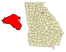
 Location of Athens in Clarke County (left) and of Clarke County in Georgia (right) | |
| Coordinates: 33°57′N 83°23′W / 33.950°N 83.383°W | |
| Country | |
| State | |
| County | Clarke |
| Settled | 1801 |
| As Town | December 1806 |
| As City | August 24, 1872 |
| Named for | Athens, Greece |
| Government | |
| • Mayor | Kelly Girtz[1] |
| Area | |
| 118.10 sq mi (305.87 km2) | |
| • Land | 116.33 sq mi (301.29 km2) |
| • Water | 1.77 sq mi (4.58 km2) |
| Elevation | 636 ft (194 m) |
| Population | |
| 127,315 | |
| • Rank | 218th in the United States 6th in Georgia |
| • Density | 1,094.43/sq mi (422.57/km2) |
| • Metro | 215,415 (212th) |
| Demonym | Athenian |
| Time zone | UTC−5 (EST) |
| • Summer (DST) | UTC−4 (EDT) |
| ZIP Codes | 30601–30609, 30612 |
| Area code | 706 |
| FIPS code | 13-03440[5] |
| Website | accgov.com |
Athens is a consolidated city-county in the U.S. state of Georgia. Downtown Athens lies about 70 miles (110 km) northeast of downtown Atlanta.[6] The University of Georgia, the state's flagship public university and an R1 research institution, is in Athens and contributed to its initial growth. In 1991, after a vote the preceding year, the original City of Athens abandoned its charter to form a unified government with Clarke County, referred to jointly as Athens–Clarke County where it is the county seat.[7]
As of 2021, the Athens-Clarke County's official website's population of the consolidated city-county (all of Clarke County except Winterville and a portion of Bogart) was 128,711.[8] Athens is the sixth-most populous city in Georgia, and the principal city of the Athens metropolitan area,[9] which had a 2020 population of 215,415, according to the U.S. Census Bureau.[4] Metropolitan Athens is a component of the larger Atlanta–Athens–Clarke County–Sandy Springs Combined Statistical Area.[10]
The city is dominated by a pervasive college town culture and music scene centered in downtown Athens, next to the University of Georgia's North Campus.[11] Major music acts associated with Athens include numerous alternative rock bands such as R.E.M., the B-52's, Widespread Panic, Drive-By Truckers, of Montreal, Neutral Milk Hotel, and Harvey Milk. The city is also known as a recording site for such groups as the Atlanta-based Indigo Girls. The 2020 book Cool Town: How Athens, Georgia, Launched Alternative Music and Changed American Culture describes Athens as the model of the indie culture of the 1980s.[12]
- ^ Holland, Maggie (May 22, 2018). "BREAKING: Kelly Girtz claims victory as Athens-Clarke County's next mayor". The Red & Black.
- ^ "2021 U.S. Gazetteer Files". United States Census Bureau. Retrieved October 13, 2021.
- ^ "QuickFacts: Savannah city, Georgia". United States Census Bureau. Retrieved October 13, 2021.
- ^ a b "2020 Population and Housing State Data". United States Census Bureau. Retrieved October 13, 2021.
- ^ "U.S. Census website". United States Census Bureau. Retrieved January 31, 2008.
- ^ "Atlanta downtown to Athens downtown". google.com. Google. Retrieved January 29, 2024.
- ^ "Unification of Athens & Clarke County". athensclarkecounty.com. Retrieved March 16, 2015.
- ^ "Demographics | Athens-Clarke County, GA - Official Website". www.accgov.com. Retrieved October 20, 2024.
- ^ "U.S. Whitehouse OMB Bulletin No. 05-02 Appendix (Code 12020*)" (PDF). Archived from the original (PDF) on March 20, 2006.
- ^ "Statistical data" (PDF). census.gov.
- ^ "Behind the Music in Athens, Georgia – Garden & Gun". Garden & Gun. November 13, 2017. Retrieved February 21, 2018.
- ^ Hale, Grace Elizabeth. Cool Town How Athens, Georgia, Launched Alternative Music and Changed American Culture. Chapel Hill: University of North Carolina Press, 2020.


