Back Maidstone District CEB Bwrdeistref Maidstone Welsh Borough of Maidstone German Municipio de Maidstone Spanish Maidstone (borough) French Maidstone (borough) Italian 메이드스톤구 Korean Meidstona (boro) Latvian/Lettish Borough of Maidstone Dutch Maidstone (distrikt) NB
Borough of Maidstone | |
|---|---|
 Jubilee Square, Maidstone | |
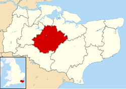
 Maidstone shown within Kent | |
| Coordinates: 51°16′24″N 0°31′20″E / 51.27333°N 0.52222°E | |
| Sovereign state | United Kingdom |
| Constituent country | England |
| Region | South East England |
| Non-metropolitan county | Kent |
| Status | Non-metropolitan district |
| Admin HQ | Maidstone |
| Incorporated | 1 April 1974 |
| Government | |
| • Type | Non-metropolitan district council |
| • Body | Maidstone Borough Council |
| • Leadership | Committees[1] (No overall control) |
| • MPs | Helen Whately Helen Grant |
| Area | |
• Total | 151.9 sq mi (393.3 km2) |
| • Rank | 87th (of 296) |
| Population (2022) | |
• Total | 180,428 |
| • Rank | 117th (of 296) |
| • Density | 1,200/sq mi (460/km2) |
| Ethnicity (2021) | |
| • Ethnic groups | |
| Religion (2021) | |
| • Religion | List
|
| Time zone | UTC0 (GMT) |
| • Summer (DST) | UTC+1 (BST) |
| ONS code | 29UH (ONS) E07000110 (GSS) |
| OS grid reference | TQ7588156056 |
The Borough of Maidstone is a local government district with borough status in Kent, England. It is named after its largest settlement of Maidstone, the county town of Kent, which is also where the council is based. The borough also includes surrounding rural areas.
The borough was formed on 1 April 1974 by the merger of the municipal borough of Maidstone with the rural districts of Maidstone and Hollingbourne, under the Local Government Act 1972.[3]
- ^ "Agenda and minutes. Council Wednesday 10th December, 2014". Maidstone Borough Council. 10 December 2014. Item 102. Archived from the original on 15 February 2017. Retrieved 15 February 2017.
- ^ a b UK Census (2021). "2021 Census Area Profile – Maidstone Local Authority (E07000110)". Nomis. Office for National Statistics. Retrieved 5 January 2024.
- ^ The County of Kent (Electoral Changes) Order 2004 Archived 10 November 2004 at the Wayback Machine
