Back Metropolregion Denver German Área metropolitana de Denver-Aurora-Broomfield Spanish Denverin metropolialue Finnish Zone métropolitaine Denver-Aurora French Area metropolitana di Denver Italian Obszar metropolitalny Denver Polish Denver metropolitan area SIMPLE ڈینور میٹروپولیٹن علاقہ Urdu Vùng đô thị Denver Vietnamese 丹佛都會區 Chinese
Denver–Lakewood–Aurora, CO Metropolitan Statistical Area | |
|---|---|
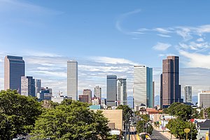
 Skyline of Downtown Denver | |
 | |
| Country | |
| State | |
| Largest city | - Denver |
| Other principal cities |
|
| Area | |
• Total | 21,770 km2 (8,405 sq mi) |
| Population | |
• Total | 2,963,821 |
| GDP | |
| • Total | $288.8 billion (2022) |
| Time zone | UTC−7 (MST) |
| • Summer (DST) | UTC−6 (MDT) |
Denver is the central city of a conurbation region in the U.S. state of Colorado. The conurbation includes one continuous region consisting of the six central counties of Adams, Arapahoe, Broomfield, Denver, Douglas, and Jefferson. The Denver region is part of the Front Range Urban Corridor and its metropolitan planning organization is the Denver Regional Council of Governments.
The United States Office of Management and Budget has delineated the Denver–Aurora–Lakewood, CO Metropolitan Statistical Area consisting of ten Colorado counties: the City and County of Denver, Arapahoe County, Jefferson County, Adams County, Douglas County, the City and County of Broomfield, Elbert County, Park County, Clear Creek County, and Gilpin County.[2] The population, as of the 2020 Census, is 2,963,821, an increase of 16.5% since 2010.[3]
The Office of Management and Budget also delineated the more extensive 12-county Denver–Aurora, CO Combined Statistical Area comprising the Denver-Aurora-Lakewood Metropolitan Statistical Area, the Boulder, CO Metropolitan Statistical Area, and the Greeley, CO Metropolitan Statistical Area.[2]
The central part of the metropolitan statistical area (MSA) includes Denver and three immediately adjacent counties: Jefferson County to the west, Adams County to the north and east, and Arapahoe County to the south and east. The continuously urbanized area extends northwest into the City and County of Broomfield, bordering Jefferson and Adams counties, and south into Douglas County, adjoining Arapahoe County. Also included in the federally defined MSA are four rural counties: Elbert County on the southeastern prairie and Clear Creek, Gilpin, and Park counties in the Rocky Mountains.
- ^ "Total Gross Domestic Product for Denver-Aurora-Lakewood, CO (MSA)". Federal Reserve Economic Data. Federal Reserve Bank of St. Louis.
- ^ a b "OMB Bulletin No. 13-01: Revised Delineations of Metropolitan Statistical Areas, Micropolitan Statistical Areas, and Combined Statistical Areas, and Guidance on Uses of the Delineations of These Areas" (PDF). Office of Management and Budget. February 28, 2013. Retrieved March 20, 2013 – via National Archives.
- ^ Star, Indianapolis. "Denver-Aurora-Lakewood, CO Metro Area Demographics and Housing 2020 Decennial Census". Indianapolis Star. Retrieved 2022-01-30.