Back Afrika Timu ACE Oos-Afrika Afrikaans ምሥራቅ አፍሪካ Amharic Afirika agan̄ Mbum-ura ANN شرق إفريقيا Arabic شرق افريقيا ARZ África Oriental AST Ronefa Afrika AVK Şərqi Afrika Azerbaijani دوغو آفریقا AZB
| East Africa | |
|---|---|
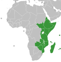
 Map of countries included in East Africa according to the UN geoscheme | |
| Countries | Sovereign states (18) |
| Territories | |
| Time zones | UTC+02:00 UTC+03:00 UTC+04:00 |
East Africa, also known as Eastern Africa or the East of Africa, is a region at the eastern edge of the African continent, distinguished by its geographical, historical, and cultural landscape. Defined in varying scopes, the region is recognized in the United Nations Statistics Division scheme as encompassing 18 sovereign states and 4 territories. It includes the Horn of Africa to the North and Southeastern Africa to the south.[1]
East Africa is acknowledged as the cradle of early modern humans, who first emerged around 200,000 to 300,000 years ago before spreading globally though Madagascar was only settled 3000 years ago.[2][3]
- ^ "United Nations Statistics Division- Standard Country and Area Codes Classifications (M49)". un.org. Archived from the original on 13 July 2011. Retrieved 22 September 2008.
- ^ Cite error: The named reference
Agegmowhshwas invoked but never defined (see the help page). - ^ Mitchell, Peter (1 October 2020). "Settling Madagascar: When Did People First Colonize the World's Largest Island?". The Journal of Island and Coastal Archaeology. 15 (4): 576–595. doi:10.1080/15564894.2019.1582567. ISSN 1556-4894.