Back Oos-Kaap Afrikaans كيب الشرقية Arabic Cabu Oriental AST Şərqi Keyp vilayəti Azerbaijani Усходне-Капская правінцыя Byelorussian Усходняя Капская правінцыя BE-X-OLD Източен Кейп Bulgarian পূর্ব কেপ Bengali/Bangla Kab ar Reter Breton Cap Oriental Catalan
Eastern Cape
| |
|---|---|
| Motto: Development through Unity | |
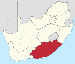
 Location of the Eastern Cape in South Africa | |
| Coordinates: 32°S 27°E / 32°S 27°E | |
| Country | |
| Established | 27 April 1994 |
| Capital | Bhisho |
| Largest city | Gqeberha (Port Elizabeth) |
| Districts | |
| Government | |
| • Type | Parliamentary system |
| • Premier | Oscar Mabuyane (ANC) |
| • Legislature | Eastern Cape Provincial Legislature |
| Area [1]: 9 | |
• Total | 168,966 km2 (65,238 sq mi) |
| • Rank | 2nd in South Africa |
| Highest elevation | 3,019 m (9,905 ft) |
| Lowest elevation | 0 m (0 ft) |
| Population (2022)[2] | |
• Total | 7,225,784 |
| • Rank | 4th in South Africa |
| • Density | 43/km2 (110/sq mi) |
| • Rank | 6th in South Africa |
| Population groups (2022) | |
| • Black | 85.7% |
| • Coloured | 7.6% |
| • White | 5.6% |
| • Indian or Asian | 0.5% |
| • Other | 0.7% |
| Languages (2022) | |
| • Xhosa | 81.8% |
| • Afrikaans | 9.6% |
| • English | 4.8% |
| • Sotho | 2.4% |
| Time zone | UTC+2 (SAST) |
| ISO 3166 code | ZA-EC |
| GDP | US$30.7 billion[3] |
| Website | www.ecprov.gov.za |
| Xhosa | iMpuma-Kapa |
|---|---|
| Afrikaans | Oos-Kaap |
| Setswana | Kapa Botlhaba |
The Eastern Cape (Xhosa: iMpuma-Kapa; Afrikaans: Oos-Kaap [ˈuəs.kɑːp]) is one of the nine provinces of South Africa. Its capital is Bhisho, and its largest city is Gqeberha (Port Elizabeth). Due to its climate and nineteenth-century towns, it is a common location for tourists. It is also known for having been home to many anti-apartheid activists, including Nelson Mandela.
The second largest province in the country (at 168,966 km2) after the Northern Cape, it was formed in 1994 out of the Xhosa homelands or bantustans of Transkei and Ciskei, together with the eastern portion of the Cape Province. The central and eastern part of the province is the traditional home of the indigenous Xhosa people. In 1820 this area, which was known as the Xhosa Kingdom, began to be settled by Europeans who originally came from England, Scotland and Ireland.
- ^ Census 2011: Census in brief (PDF). Pretoria: Statistics South Africa. 2012. ISBN 9780621413885. Archived (PDF) from the original on 13 May 2015.
- ^ a b c "Statistical Release - Census 2022" (PDF). statssa.gov.za. Retrieved 22 August 2024.
- ^ "Provincial gross domestic product:experimental estimates, 2013–2022" (PDF), www.statssa.gov.za
- ^ "Sub-national HDI – Area Database – Global Data Lab". hdi.globaldatalab.org. Archived from the original on 23 September 2018. Retrieved 13 September 2018.
