Back ফ্লাকস্টাড BPY Flakstad Catalan Flakstad CEB Flakstad Danish Flakstad German Flakstad Esperanto Flakstad Spanish Flakstad Basque Flakstad Finnish Flakstad French
Flakstad Municipality
Flakstad kommune | |
|---|---|
 View of a beach in Flakstad | |
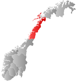
 Nordland within Norway | |
 Flakstad within Nordland | |
| Coordinates: 68°04′45″N 13°16′28″E / 68.07917°N 13.27444°E | |
| Country | Norway |
| County | Nordland |
| District | Lofoten |
| Established | 1 Jan 1838 |
| • Created as | Formannskapsdistrikt |
| Disestablished | 1 Jan 1964 |
| • Succeeded by | Moskenes Municipality |
| Re-established | 1 Jan 1976 |
| • Preceded by | Moskenes Municipality |
| Administrative centre | Ramberg |
| Government | |
| • Mayor (2023) | Einar Benjaminsen (LL) |
| Area | |
• Total | 178.54 km2 (68.93 sq mi) |
| • Land | 169.23 km2 (65.34 sq mi) |
| • Water | 9.31 km2 (3.59 sq mi) 5.2% |
| • Rank | #312 in Norway |
| Highest elevation | 938.71 m (3,079.76 ft) |
| Population (2024) | |
• Total | 1,229 |
| • Rank | #318 in Norway |
| • Density | 6.9/km2 (18/sq mi) |
| • Change (10 years) | |
| Demonym | Flakstadfjerding[2] |
| Official language | |
| • Norwegian form | Neutral |
| Time zone | UTC+01:00 (CET) |
| • Summer (DST) | UTC+02:00 (CEST) |
| ISO 3166 code | NO-1859[4] |
| Website | Official website |
Flakstad is a municipality in Nordland county, Norway. It is part of the traditional district of the island group Lofoten. The administrative centre of the municipality is the village of Ramberg. Other villages in the municipality include Fredvang, Napp, Nusfjord, Sund, and Vareid.

The municipality is located in the Lofoten Islands and comprises the entire island of Flakstadøya and the northern part of the island of Moskenesøya, plus many smaller islets surrounding the main islands. The European route E10 highway runs across the whole municipality.
The 179-square-kilometre (69 sq mi) municipality is the 312th largest by area out of the 357 municipalities in Norway. Flakstad is the 318th most populous municipality in Norway with a population of 1,229. The municipality's population density is 6.9 inhabitants per square kilometre (18/sq mi) and its population has decreased by 10.2% over the previous 10-year period.[5][6]
- ^ "Høgaste fjelltopp i kvar kommune" (in Norwegian). Kartverket. 16 January 2024.
- ^ "Navn på steder og personer: Innbyggjarnamn" (in Norwegian). Språkrådet.
- ^ "Forskrift om målvedtak i kommunar og fylkeskommunar" (in Norwegian). Lovdata.no.
- ^ Bolstad, Erik; Thorsnæs, Geir, eds. (9 January 2024). "Kommunenummer". Store norske leksikon (in Norwegian). Foreningen Store norske leksikon.
- ^ Statistisk sentralbyrå. "Table: 06913: Population 1 January and population changes during the calendar year (M)" (in Norwegian).
- ^ Statistisk sentralbyrå. "09280: Area of land and fresh water (km²) (M)" (in Norwegian).

