Back Hispaniola Afrikaans Hispaniola ALS Hispaniola AN Lytel Spēonland ANG هسبنيولا Arabic هيسبانيولا ARZ La Española AST Haiti adası Azerbaijani Гаити (утрау) Bashkir Гаіці (востраў) Byelorussian
| |
|---|---|
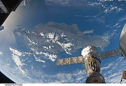
 View from the ISS, 2011 | |
 | |
| Geography | |
| Location | Caribbean Sea |
| Coordinates | 19°N 71°W / 19°N 71°W |
| Archipelago | Greater Antilles |
| Major islands | |
| Area | 76,192 km2 (29,418 sq mi) |
| Area rank | 22nd |
| Coastline | 3,059 km (1900.8 mi) |
| Highest elevation | 3,175 m (10417 ft)[1] |
| Highest point | Pico Duarte |
| Administration | |
| Capital and largest city | Santo Domingo (pop. 1,029,117[3]) |
| Area covered | 48,445 km2 (18,705 sq mi; 63.6%) |
| Capital and largest city | Port-au-Prince (pop. 1,234,742) |
| Area covered | 27,747 km2 (10,713 sq mi; 36.4%) |
| Demographics | |
| Population | 22,569,800 (2024; both countries' estimates combined) |
| Pop. density | 280.8/km2 (727.3/sq mi) |
| Ethnic groups | Dominicans, Haitians |
Hispaniola (/ˌhɪspənˈjoʊlə/,[5][6][7] also UK: /-pænˈ-/)[8][9][10][11] is an island between Cuba and Puerto Rico in the Greater Antilles of the Caribbean. Hispaniola is the most populous island in the West Indies, and the second-largest by land area, after Cuba. The 76,192-square-kilometre (29,418 sq mi) island is divided into two separate sovereign countries: the Spanish-speaking Dominican Republic (48,445 km2 (18,705 sq mi) to the east and the French and Haitian Creole–speaking Haiti (27,750 km2 (10,710 sq mi) to the west. The only other divided island in the Caribbean is Saint Martin, which is shared between France (Saint Martin) and the Netherlands (Sint Maarten).
Hispaniola is the site of one of the first European forts in the Americas, La Navidad (1492–1493), as well as the first settlement La Isabela (1493–1500), and the first permanent settlement, the current capital of the Dominican Republic, Santo Domingo (est. 1498). These settlements were founded successively during each of Christopher Columbus's first three voyages.[12][13][14][15]
The Spanish Empire controlled the entire island of Hispaniola from the 1490s until the 17th century, when French pirates began establishing bases on the western side of the island. The official name was La Española, meaning "The Spanish (Island)". It was also called Santo Domingo, after Saint Dominic.
- ^ "Field Listing—Elevation extremes". The World Factbook. Central Intelligence Agency. Archived from the original on June 13, 2007.
- ^ "Dominican Republic". The World Factbook (2025 ed.). Central Intelligence Agency. Retrieved December 5, 2024.
- ^ "Provincias Dominicanas" (PDF). Retrieved December 5, 2024.
- ^ "Haiti". The World Factbook (2025 ed.). Central Intelligence Agency. Retrieved December 5, 2024.
- ^ "Hispaniola". The American Heritage Dictionary of the English Language (5th ed.). HarperCollins. Retrieved July 22, 2019.
- ^ "Hispaniola". Collins English Dictionary. HarperCollins. Retrieved July 22, 2019.
- ^ "Hispaniola". Merriam-Webster.com Dictionary. Merriam-Webster. Retrieved July 22, 2019.
- ^ "Hispaniola". Lexico UK English Dictionary. Oxford University Press. Archived from the original on December 2, 2020.
- ^ Spanish: La Española; translation: That That Is Spanish; Latin and French: Hispaniola; Haitian Creole: Ispayola; Taino: Ayiti or Quisqueya)
- ^ Anglería, Pedro Mártir de (1949). Décadas del Nuevo Mundo, Tercera Década, Libro VII (in Spanish). Buenos Aires: Editorial Bajel.
- ^ Las Casas, Fray Bartolomé de (1966). Apologética Histórica Sumaria (in Spanish). Mexico: UNAM.
- ^ "Embassy of the Dominican Republic, in the United States". Archived from the original on May 24, 2007. Retrieved February 27, 2009.
- ^ "Haiti". The World Factbook. Central Intelligence Agency. October 6, 2021.
- ^ Davies, Arthur (1953). "The Loss of the Santa Maria Christmas Day, 1492". The American Historical Review: 854–865. doi:10.1086/ahr/58.4.854.
- ^ Maclean, Frances (January 2008). "The Lost Fort of Columbus". Smithsonian. Retrieved January 24, 2008.