Back كروار Arabic Karwar BAR কারওয়ার Bengali/Bangla কারৱার BPY Karwar Catalan Karwar (lungsod sa Indiya) CEB Karwar German Karwar Spanish کروار Persian Karwar French
This article needs additional citations for verification. (November 2022) |
Karwar
Kādwād Carwar | |
|---|---|
Municipality /Taluk | |
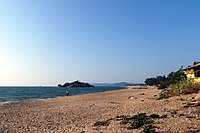
Clockwise from the Top: Tagore Beach, Arabian Sea from Sadashivgad fort, Majali Beach, Bridge over Kali River | |
 Karwar in Karnataka | |
| Coordinates: 14°48′N 74°08′E / 14.80°N 74.13°E | |
| Country | |
| State | Karnataka |
| District | Uttara Kannada |
| Government | |
| • Type | City Municipal Council |
| Area | |
| • Urban | 36.95 km2 (14.27 sq mi) |
| • Taluk | 743.4 km2 (287.0 sq mi) |
| Elevation | 6 m (20 ft) |
| Population (2011)[2] | |
| • CMC+Outgrowth | 77,139 |
| • Taluk | 155,213 |
| Demonym | Karwarkar |
| Time zone | UTC+5:30 (IST) |
| PIN | 581301 |
| Telephone code | 91-8382 |
| Vehicle registration | KA 30 |
| Official language | Kannada[3] |
| HDI (2014) | |
| Literacy (2014) | 89.91[4] |
| Sex ratio (2014) | 989 ♀/1000 ♂[4] |
| Website | karwarcity |
Karwar, also pronounced as Kārawāra is a seaside city and headquarters of Uttara Kannada district lying at the mouth of Kali river in the Karnataka state of India.
- ^ "Karwar city population". www.citypopulation.de/en.
- ^ "Sub-District Details". Office of the Registrar General & Census Commissioner, India. Retrieved 27 March 2012.
- ^ "50th Report of the Commissioner for Linguistic Minorities in India (July 2012 to June 2013)" (PDF). Archived from the original (PDF) on 8 July 2016. Retrieved 14 January 2015.
- ^ a b c Zilla Panchayat Uttara Kannada District Overview 2014 http://www.zpkarwar.kar.nic.in/docs/publication/English/EnglishPart2.pdf


