Back Lena Afrikaans Lena (Fluss) ALS نهر لينا Arabic واد لينا ARY نهر لينا ARZ Ríu Lena AST Lena AVK Lena çayı Azerbaijani لنا چایی AZB Лена Bashkir
| Lena | |
|---|---|
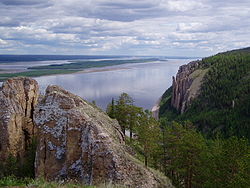
 The Lena Pillars along the river near Yakutsk | |
 Lena watershed | |
 | |
| Native name | |
| Location | |
| Country | Russia |
| Physical characteristics | |
| Source | Baikal Mountains |
| • location | Kachugsky District, Irkutsk Oblast |
| • coordinates | 53°59′40″N 107°52′33″E / 53.99444°N 107.87583°E (approximately) |
| • elevation | 1,640 m (5,380 ft) |
| Mouth | Lena Delta |
• location | Arctic Ocean, Laptev Sea |
• coordinates | 72°24′31″N 126°41′05″E / 72.4087°N 126.6847°E |
• elevation | 0 m (0 ft) |
| Length | 4,294 km (2,668 mi) |
| Basin size | 2,460,742 km2 (950,098 sq mi) to 2,490,000 km2 (960,000 sq mi) |
| Width | |
| • maximum | 10,000 m (33,000 ft) |
| Depth | |
| • maximum | 28 m (92 ft) |
| Discharge | |
| • location | Kyusyur, Russia (Basin size: 2,440,000 km2 (940,000 sq mi) to 2,418,974 km2 (933,971 sq mi)[1] |
| • average | (Period of data: 1971–2015)17,773 m3/s (627,600 cu ft/s)[1]
(Period of data: 1970–1999)17,067 m3/s (602,700 cu ft/s)[2] 15,500 m3/s (550,000 cu ft/s)[3] |
| • minimum | 366 m3/s (12,900 cu ft/s) |
| • maximum | 241,000 m3/s (8,500,000 cu ft/s)
Lena Delta, Laptev Sea, Russia (Period of data: 1984–2018)577 km3/a (18,300 m3/s)[1] (Period of data: 1940–2019) 545.7 km3/a (17,290 m3/s)[4] |
| Discharge | |
| • location | Vilyuy |
| • average | 12,100 m3/s (430,000 cu ft/s)
Tabaga, Yakutsk (Basin size: 987,000 km2 (381,000 sq mi) (Period of data: 1967–2017) 7,453.2 m3/s (263,210 cu ft/s)[5] (max. 51,600 m3/s (1,820,000 cu ft/s))[5] |
| Discharge | |
| • location | Olyokminsk |
| • average | 4,500 m3/s (160,000 cu ft/s) |
| Discharge | |
| • location | Vitim |
| • average | 1,700 m3/s (60,000 cu ft/s) |
| Discharge | |
| • location | Kirensk |
| • average | 480 m3/s (17,000 cu ft/s) |
| Basin features | |
| Tributaries | |
| • left | Vilyuy |
| • right | Kirenga, Vitim, Olyokma, Aldan |
The Lena is a river in the Russian Far East and is the easternmost river of the three great rivers of Siberia which flow into the Arctic Ocean, the others being Ob and Yenisey.[note 1] The Lena river is 4,294 km (2,668 mi) long and has a capacious drainage basin of 2,490,000 km2 (960,000 sq mi); thus the Lena is the eleventh-longest river in the world and the longest river entirely within Russia.[6] Geographically, permafrost underlies all the Lena River's catchment and it is continuous in over 75 percent of the basin.[7]
- ^ a b c Stadnyk, Tricia A.; Tefs, A.; Broesky, M.; Déry, S. J.; Myers, P. G.; Ridenour, N. A.; Koenig, K.; Vonderbank, L.; Gustafsson, D. (28 May 2021). "Changing freshwater contributions to the Arctic". Elementa: Science of the Anthropocene. 9 (1): 00098. Bibcode:2021EleSA...9...98S. doi:10.1525/elementa.2020.00098. S2CID 236682638.
- ^ "Variations of the Present-Day Annual and Seasonal Runoff in the Far East and Siberia with the Use of Regional Hydrological and Global Climate Models" (PDF). 2018.
- ^ http://www.abratsev.narod.ru/biblio/sokolov/p1ch23b.html, Sokolov, Eastern Siberia // Hydrography of USSR. (in russian)
- ^ "River Discharge". Arctic Program.
- ^ a b Gautier, Emmanuèle; Dépret, Thomas; Cavero, Julien; Costard, François; Virmoux, Clément; Fedorov, Alexander; Konstantinov, Pavel; Jammet, Maël; Brunstein, Daniel (August 2021). "Fifty-year dynamics of the Lena River islands (Russia): Spatio-temporal pattern of large periglacial anabranching river and influence of climate change" (PDF). Science of the Total Environment. 783: 147020. Bibcode:2021ScTEn.78347020G. doi:10.1016/j.scitotenv.2021.147020. PMID 34088165. S2CID 234836524.
- ^ "Река Лена in the State Water Register of Russia". textual.ru (in Russian).
- ^ Hiyama Tetsuya; Park Hotaek; Kobayashi Kota; Lebedeva, Liudmila; Gustafsson, David (January 2023). "Contribution of summer net precipitation to winter river discharge in permafrost zone of the Lena River basin". Journal of Hydrology. 616.
Cite error: There are <ref group=note> tags on this page, but the references will not show without a {{reflist|group=note}} template (see the help page).