| Linggi River | |
|---|---|
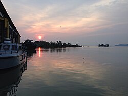
 A pier at the mouth of the Linggi, near the Negeri Sembilan-Malacca state border. | |
| Native name | Sungai Linggi (Malay) |
| Location | |
| Country | Malaysia |
| State | Negeri Sembilan and Malacca |
| Physical characteristics | |
| Source | Titiwangsa Mountains |
| • location | Pantai, Seremban District, Negeri Sembilan |
| • coordinates | 2°49′02″N 101°59′14″E / 2.8172°N 101.9872°E |
| Mouth | Strait of Malacca |
• location | Kuala Linggi, Alor Gajah District, Malacca and Kampung Tanjung Agas, Port Dickson District, Negeri Sembilan |
• coordinates | 2°23′26″N 101°58′26″E / 2.3906°N 101.9738°E |
| Length | 83.5 km (51.9 mi) |
| Basin features | |
| Tributaries | |
| • right | Semin River Rembau River |
| Bridges | Jambatan Kampung Barisan Jambatan Jalan Rantau Jambatan Kuala Linggi |
| Inland ports | Port of Kuala Sungai Linggi |

The Linggi River (Malay: Sungai Linggi) is a river in Malaysia which flows through the states of Negeri Sembilan and Malacca. It is one of two major rivers that serve as water sources for most of Negeri Sembilan's population, the other being the Muar River, which constitutes the state's eastern half.


