Back Nottinghamshire Afrikaans Snotingahāmscīr ANG نوتنغهامشير Arabic نوتنجهامشير ARZ Nottinghamshire AST Nottinghamshire BAN Nottinghamshire BAR Нотынгемшыр Byelorussian Нотынггэмшыр BE-X-OLD Нотингамшър Bulgarian
This article needs additional citations for verification. (December 2017) |
Nottinghamshire | |
|---|---|
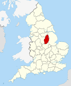
 Nottinghamshire within England | |
| Coordinates: 53°N 1°W / 53°N 1°W | |
| Sovereign state | United Kingdom |
| Constituent country | England |
| Region | East Midlands |
| Established | Ancient |
| Time zone | UTC+0 (GMT) |
| • Summer (DST) | UTC+1 (BST) |
| UK Parliament | 8 MPs |
| Police | Nottinghamshire Police |
| Ceremonial county | |
| Lord Lieutenant | Lady Veronica Pickering |
| High Sheriff | Nick Rubins (2024/25) |
| Area | 2,159 km2 (834 sq mi) |
| • Rank | 27th of 48 |
| Population (2022)[1] | 1,163,335 |
| • Rank | 15th of 48 |
| Density | 539/km2 (1,400/sq mi) |
| Ethnicity |
|
| Non-metropolitan county | |
| County council | Nottinghamshire County Council |
| Control | Conservative |
| Admin HQ | County Hall, West Bridgford |
| Area | 2,085 km2 (805 sq mi) |
| • Rank | 14th of 21 |
| Population (2022)[3] | 834,822 |
| • Rank | 10th of 21 |
| Density | 400/km2 (1,000/sq mi) |
| ISO 3166-2 | GB-NTT |
| GSS code | E10000024 |
| ITL | TLF15/16 |
| Website | nottinghamshire |
| Districts | |
 Districts of Nottinghamshire Unitary County council area | |
| Districts | |
Nottinghamshire (/ˈnɒtɪŋəmʃər, -ʃɪər/;[4] abbreviated Notts.) is a ceremonial county in the East Midlands of England. The county borders South Yorkshire to the north-west, Lincolnshire to the east, Leicestershire to the south, and Derbyshire to the west. The largest settlement is the city of Nottingham (323,632), which is also the county town.
The county has an area of 2,160 km2 (830 sq mi) and a population of 1,154,195. The latter is concentrated in the Nottingham built-up area in the south-west, which extends into Derbyshire and has a population of 729,997. The north-east of the county is more rural, and contains the towns of Worksop (44,733) and Newark-on-Trent (27,700). For local government purposes Nottinghamshire comprises a non-metropolitan county, with seven districts, and the Nottingham unitary authority area. The East Midlands Combined County Authority includes Nottinghamshire County Council and Nottingham City Council.
The geography of Nottinghamshire is largely defined by the River Trent, which forms a wide valley which crosses the county from the south-west to the north-east. North of this, in the centre of the county, is Sherwood Forest, the remnant of a large ancient woodland.
- ^ "Mid-2022 population estimates by Lieutenancy areas (as at 1997) for England and Wales". Office for National Statistics. 24 June 2024. Retrieved 26 June 2024.
- ^ "Nottinghamshire Demographics | Age, Ethnicity, Religion, Wellbeing". Varbes. Retrieved 10 February 2023.
- ^ "Mid-Year Population Estimates, UK, June 2022". Office for National Statistics. 26 March 2024. Retrieved 3 May 2024.
- ^ "Definition of 'Nottinghamshire' – British English pronunciation". www.CollinsDictionary.com. Collins English Dictionary. Archived from the original on 24 December 2017. Retrieved 23 December 2017.


