Back Papua (propinsi) ACE Papoea (provinsie) Afrikaans بابوا (إندونيسيا) Arabic Papua BAN Papua BBC Папуа (правінцыя, Інданезія) Byelorussian Papua (propinsi) BEW Папуа (провинция) Bulgarian পাপুয়া (প্রদেশ) Bengali/Bangla Província de Papua Catalan
Papua | |
|---|---|
| Province of Papua Provinsi Papua | |
| Nickname(s): | |
| Motto(s): | |
 | |
| Coordinates (Jayapura): 2°32′S 140°43′E / 2.533°S 140.717°E | |
| Country | |
| Establishment | 27 December 1949[1] |
| Indonesian administration | 1 May 1963[2] |
| Latest partition | 30 June 2022[3] |
| Capital and largest city | Jayapura |
| Divisions | 8 regencies and 1 city |
| Government | |
| • Body | Papua Provincial Government |
| • Governor | Ramses Limbong (acting) |
| • Vice Governor | Vacant |
| Area | |
• Total | 82,680.95 km2 (31,923.29 sq mi) |
| • Rank | 7th in Indonesia |
| Population (mid 2024 estimation)[5] | |
• Total | 1,060,550 |
| • Density | 13/km2 (33/sq mi) |
| Time zone | UTC+09:00 (Indonesia Eastern Time) |
| ISO 3166 code | ID-PA |
| Vehicle registration | PA |
| HDI (2024) | |
| Website | papua |
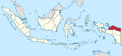
Papua is a province of Indonesia, comprising the northern coast of Western New Guinea together with island groups in Cenderawasih Bay to the west. It roughly follows the borders of Papuan customary region of Tabi Saireri,[7][8] and is divided into eight regencies (kabupaten) and one city (kota), the latter being the provincial capital of Jayapura.
It is bordered by nation of Papua New Guinea to the east, the Pacific Ocean to the north, Cenderawasih Bay to the west, and the provinces of Central Papua and Highland Papua to the south. The province also shares maritime boundaries with Palau in the Pacific. Papua, along with the five other Papuan provinces,[citation needed] has a higher degree of autonomy level compared to other Indonesian provinces.[9]
Prior to 2003, the province (known as Irian Barat from 1962 to 1973 and Irian Jaya from 1973 to 2002) covered the entirety of Western New Guinea, a region also known as "Papua". In 2002, Papua adopted its current name and was granted a special autonomous status under Indonesian legislation. In 2001, the western end of the province was split off into a new province of West Papua, and in July 2022 the provinces of Central Papua, Highland Papua, and South Papua were also split off, leaving the current province covering a much smaller northern area around Jayapura, the northern part of the former province, and the islands in the Cenderawasih Bay.
The official estimate of the population in mid 2024 of the province under its current borders was 1,060,550 (comprising 554,800 males and 505,800 females).[5]
- ^ "PERDA Provinsi Papua No 6 Tahun 2016" (PDF). peraturan.bpk.go.id. Retrieved 22 April 2021.
- ^ "Penetapan Presiden RI No 1 Tahun 1963" (PDF). bphn.go.id. Archived from the original (PDF) on 6 July 2022. Retrieved 2 August 2022.
- ^ "DPR Sahkan 3 UU Provinsi Baru, Puan: Jaminan Hak Rakyat Papua dalam Pemerataan Pembangunan". Archived from the original on 4 July 2022. Retrieved 4 July 2022.
- ^ Faisal, M. (8 August 2022). "5 Provinsi di Pulau Papua". Kompas.com (in Indonesian). Retrieved 11 September 2022.
- ^ a b Badan Pusat Statistik, Jakarta, 28 February 2025, Provinsi Papua Dalam Angka 2025 (Katalog-BPS 1102001.91)
- ^ "Indeks Pembangunan Manusia 2024" (in Indonesian). Statistics Indonesia. 2024. Retrieved 15 November 2024.
- ^ "Wilayah Adat Tabi Saireri Sepakati 11 Poin Evaluasi Otsus". 29 August 2020.
- ^ "Pertemuan Forum Kepala Daerah Tabi Saireri, ini sejumlah Agenda yang dibahas". Yapen Islands Regency Official Website. 30 July 2020. Retrieved 5 July 2022.[dead link]
- ^ "Perubahan Kedua atas Undang-Undang Nomor 21 Tahun 2001 tentang Otonomi Khusus bagi Provinsi Papua". peraturan.bpk.go.id. Retrieved 5 January 2023.

