Back پارادیس والئی، نوادا AZB Paradise Valley (lungsod sa Tinipong Bansa, Nevada, Humboldt County, lat 41,49, long -117,53) CEB Paradise Valley (Nevada) Spanish Paradise Valley (Nevada) Basque پرادایس ولی، نوادا Persian Paradise Valley (Nevada) French پرادایس ولي (نوادا) GLK Paradise Valley, Nevada HT Paradise Valley (Nevada) Italian Paradise Valley (Nevada) LLD
Paradise Valley, Nevada | |
|---|---|
 | |
| Coordinates: 41°29′35″N 117°31′59″W / 41.49306°N 117.53306°W | |
| Country | United States |
| State | Nevada |
| County | Humboldt |
| Area | |
• Total | 3.43 sq mi (8.88 km2) |
| • Land | 3.42 sq mi (8.87 km2) |
| • Water | 0.00 sq mi (0.01 km2) |
| Elevation | 4,557 ft (1,389 m) |
| Population (2020) | |
• Total | 71 |
| • Density | 20.73/sq mi (8.00/km2) |
| Time zone | UTC-8 (Pacific (PST)) |
| • Summer (DST) | UTC-7 (PDT) |
| ZIP codes | 89426 |
| FIPS code | 32-55400 |
| GNIS feature ID | 2583950[2] |
| Reference no. | 89 |
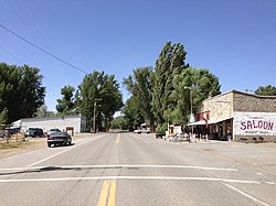
Paradise Valley is a census-designated place (CDP) in Humboldt County, Nevada, United States, near the Santa Rosa Ranger District of Humboldt National Forest. It is located at the northern terminus of Nevada State Route 290, about 19 miles (31 km) northeast of U.S. Highway 95 and a total of 40 miles (64 km) north of Winnemucca. The town is located in a broad valley, with the Santa Rosa Range of mountains just to the northwest. At the 2010 census, the population of the CDP was 109.[3]
- ^ "ArcGIS REST Services Directory". United States Census Bureau. Retrieved September 19, 2022.
- ^ a b U.S. Geological Survey Geographic Names Information System: Paradise Valley, Nevada
- ^ "Geographic Identifiers: 2010 Demographic Profile Data (G001): Paradise Valley CDP, Nevada". U.S. Census Bureau, American Factfinder. Archived from the original on February 12, 2020. Retrieved January 24, 2013.

