Back Putumayo (departement) Afrikaans إدارة بوتومايو Arabic Putumayo (departament) Azerbaijani Putumaja departaments BAT-SMG Путумайо Bulgarian Putumayo (Colombia) Breton Departament de Putumayo Catalan Departamento del Putumayo CEB Putumayo (departement) Czech Departamento de Putumayo German
Department of Putumayo
Departamento del Putumayo | |
|---|---|
 Green Hills around Mocoa | |
|
| |
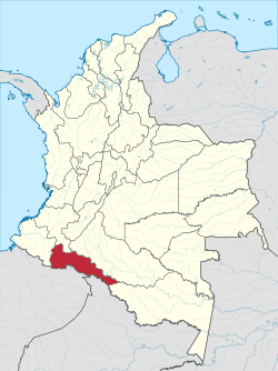
 Putumayo shown in red | |
 Topography of the department | |
| Coordinates: 1°09′N 76°37′W / 1.150°N 76.617°W | |
| Country | |
| Region | Amazonía Region |
| Established | 1991 |
| Capital | Mocoa |
| Government | |
| • Governor | Sorrel Parisa Aroca Rodriguez(2016-2019) |
| Area | |
• Total | 24,885 km2 (9,608 sq mi) |
| • Rank | 16th |
| Population (2018)[3] | |
• Total | 348,182 |
| • Rank | 26th |
| • Density | 14/km2 (36/sq mi) |
| GDP | |
| • Total | COP 5,617 billion (US$ 1.3 billion) |
| Time zone | UTC-05 |
| ISO 3166 code | CO-PUT |
| Municipalities | 13 |
| HDI (2019) | 0.717[5] high · 26th of 33 |
| Website | www.putumayo.gov.co |
Putumayo (Spanish pronunciation: [putuˈmaʝo]) is a department of Southern Colombia. It is in the south-west of the country, bordering Ecuador and Peru. Its capital is Mocoa.
The word putumayo comes from the Quechua languages. The verb p'utuy means "to spring forth" or "to burst out", and mayu means river. Thus it means "gushing river".
- ^ "Nuestro departamento: Información general". Gobernación del Putumayo.
- ^ Kline, Harvey F. (2012). "Putumayo, Department of". Historical Dictionary of Colombia. Lanham, Maryland: Scarecrow Press. p. 415. ISBN 978-0-8108-7813-6.
- ^ "DANE". Archived from the original on 13 November 2009. Retrieved 13 February 2013.
- ^ "Producto Interno Bruto por departamento", www.dane.gov.co
- ^ "Sub-national HDI - Area Database - Global Data Lab". hdi.globaldatalab.org. Retrieved 13 September 2018.

