Back سان لويس (أريزونا) Arabic سان لويس ARZ سان لوئیس، آریزونا AZB San Luis, Arizona BAR Сан Луис Bulgarian San Luis (Arizona) Catalan Сан-Луис (Аризона) CE San Luis (lungsod sa Tinipong Bansa, Arizona) CEB San Luis (Arizona) Czech San Luis, Arizona Welsh
San Luis | |
|---|---|
 Border wall between the United States and Mexico in San Luis | |
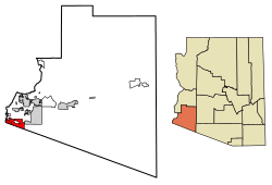
 Location of San Luis in Yuma County, Arizona. | |
| Coordinates: 32°29′35″N 114°44′26″W / 32.49306°N 114.74056°W | |
| Country | United States |
| State | Arizona |
| County | Yuma |
| Founded | 1930 |
| Incorporated | 1979 |
| Government | |
| • Type | Council-Manager |
| • Body | San Luis City Council |
| Area | |
• Total | 34.10 sq mi (88.32 km2) |
| • Land | 34.02 sq mi (88.13 km2) |
| • Water | 0.07 sq mi (0.19 km2) 0.11% |
| Elevation | 167 ft (51 m) |
| Population (2020) | |
• Total | 35,257 |
| • Density | 1,036.21/sq mi (400.08/km2) |
| Time zone | UTC-7 (MST) |
| ZIP code | 85349, 85336, 85350 |
| Area code | 928 |
| FIPS code | 04-63470 |
| GNIS feature ID | 2411795[2] |
| Website | www.sanluisaz.gov |
San Luis is a city in Yuma County, Arizona, United States. The population was 35,257 at the 2020 census.[3] It is part of the Yuma Metropolitan Statistical Area. San Luis, located in the southwest corner of the state directly adjacent to Mexico's Federal Highway 2 at San Luis Rio Colorado, was the second fastest-growing city or town in Arizona from 1990 to 2000. According to 2022 Census Bureau estimates, the population of the city is 35,770.[4]
- ^ "2020 U.S. Gazetteer Files". United States Census Bureau. Retrieved October 29, 2021.
- ^ a b U.S. Geological Survey Geographic Names Information System: San Luis, Arizona
- ^ "U.S. Census website". United States Census Bureau. Retrieved September 21, 2023.
- ^ "Population and Housing Unit Estimates". Retrieved September 21, 2023.


