Back Shinjuku, Tokyo ACE شينجوكو (طوكيو) Arabic شينجوكو ARZ Şincuku Azerbaijani Shinjuku Catalan Синдзюку CE Shinjuku-ku CEB شینجوکو CKB Šindžuku (Tokio) Czech Shinjuku Danish
This article has multiple issues. Please help improve it or discuss these issues on the talk page. (Learn how and when to remove these messages)
|
Shinjuku
新宿区 | |
|---|---|
| Shinjuku City[1] | |
Clockwise from top:
| |
 Location of Shinjuku in Tokyo | |
| Coordinates: 35°42′5″N 139°42′35″E / 35.70139°N 139.70972°E | |
| Country | Japan |
| Region | Kantō |
| Prefecture | Tokyo |
| Government | |
| • Mayor | Kenichi Yoshizumi |
| • Tourism Ambassador | Godzilla[2] |
| Area | |
• Total | 18.23 km2 (7.04 sq mi) |
| Population (1 October, 2020[3]) | |
• Total | 349,385 |
| • Density | 19,000/km2 (50,000/sq mi) |
| Time zone | UTC+9 (Japan Standard Time) |
| - Tree | Zelkova serrata |
| - Flower | Azalea |
| Phone number | 03-3209-1111 |
| City Hall Address | Kabukichō 1-4-1, Shinjuku-ku, Tokyo 160-8484 |
| Website | www |
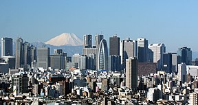
Shinjuku (Japanese: 新宿区, Hepburn: Shinjuku-ku, IPA: [ɕiɲdʑɯkɯ] ⓘ), officially called Shinjuku City, is a special ward of Tokyo, Japan. It is a major commercial and administrative center, housing the northern half of the busiest railway station in the world (Shinjuku Station) as well as the Tokyo Metropolitan Government Building, the administrative center of the Tokyo Metropolitan Government. As of 2018[update], the ward has an estimated population of 346,235 and a population density of 18,232 people per km2. The total area is 18.23 km2.[4] Since the end of World War II, Shinjuku has become a major secondary center of Tokyo (fukutoshin), rivaling the original city center in Marunouchi.
"Shinjuku" is also commonly used to refer to the entire area surrounding Shinjuku Station. The southern half of this area and majority of the station are in fact located in the neighboring Shibuya ward.
- ^ Shinjuku City Archived 2008-02-09 at the Wayback Machine
- ^ Izadi, Elahi (April 9, 2015). "Terrifying monster named Tokyo's new tourism ambassador". The Washington Post. Retrieved September 15, 2018.
- ^ "Population by District". Tokyo Statistical Yearbook. Retrieved July 15, 2022.
- ^ Shinjuku City[permanent dead link]


