Back De Cymru Catalan De Cymru Welsh South Wales Danish Südwales German Gales del Sur Spanish Hegoaldeko Gales Basque ولز جنوبی Persian Etelä-Wales Finnish Pays de Galles méridional French Wales Selatan ID

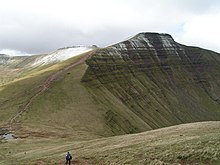
South Wales (Welsh: De Cymru [ˌdeː ˌkəmri]) is a loosely defined region of Wales bordered by England to the east and mid Wales to the north. Generally considered to include the historic counties of Glamorgan and Monmouthshire, south Wales extends westwards to include Carmarthenshire and Pembrokeshire. In the western extent, from Swansea westwards, local people would probably recognise that they lived in both south Wales and west Wales.[1] The Brecon Beacons National Park covers about a third of south Wales, containing Pen y Fan, the highest British mountain south of Cadair Idris in Snowdonia.

2,907 ft (886 metres)

A point of some discussion is whether the first element of the name should be capitalised: 'south Wales' or 'South Wales'. As the name is a geographical expression rather than a specific area with well-defined borders, style guides such as those of the BBC[2] and The Guardian[3] use the form 'south Wales'. In a more authoritative style guide, the Welsh Government, in their international gateway website, Wales.com, state that it should always be capitalised.[4] It is always capitalised on motorway signs.
- ^ "People", Culture, Wales, UK: The BBC.
- ^ BBC Academy, 'Grammar, spelling and punctuation'. Retrieved 27 December 2015.
- ^ The Guardian, 'Guardian and Observer style guide: C '. Retrieved 27 December 2015.
- ^ Wales.com, 'Language and style guidance'. Retrieved 1 July 2021.