Back نهر سانت. چوزيف ARZ Saint Joseph River (suba sa Tinipong Bansa, Michigan) CEB St. Joseph River (Lake Michigan) Danish St. Joseph River (Michigansee) German Rivero St. Joseph Esperanto Rivière Saint-Joseph (Lac Michigan) French St. Joseph (fiume Lago Michigan) Italian Sent Džozefas (Mičigano upė) Lithuanian Сент-Джозеф (река, впадает в озеро Мичиган) Russian St. Joseph (flod) Swedish
| St. Joseph River | |
|---|---|
 | |
 | |
| Native name | Sakiwäsipi (Miami-Illinois)[1] |
| Location | |
| Country | United States |
| State | Michigan, Indiana |
| Physical characteristics | |
| Source | Baw Beese Lake |
| • location | Hillsdale, Michigan |
| • coordinates | 41°54′18″N 084°36′57″W / 41.90500°N 84.61583°W[3] |
| • elevation | 1,096 ft (334 m) |
| Mouth | Lake Michigan |
• location | St. Joseph, Michigan |
• coordinates | 42°06′51″N 086°29′18″W / 42.11417°N 86.48833°W[3] |
• elevation | 581 ft (177 m)[3] |
| Length | 210 mi (340 km) |
| Discharge | |
| • location | mouth |
| • average | 5,022.45 cu ft/s (142.220 m3/s) (estimate)[4] |
| Basin features | |
| Tributaries | |
| • left | Coldwater River, Swan Creek, Prairie River, Fawn River, Pigeon River, Elkhart River, Little Elkhart River |
| • right | Nottawa Creek, Portage River, Rocky River, Dowagiac River, Paw Paw River |
| GNIS ID | 1624891 |
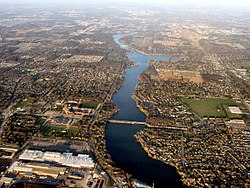
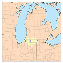
The St. Joseph River (known locally as the St. Joe) is a 210-mile-long (340 km) river that flows in a generally westerly direction through southern Michigan and northern Indiana, United States, before emptying into Lake Michigan. The St. Joseph River drainage basin covers 4,685 square miles (12,130 km2), and is the third largest watershed draining to Lake Michigan. The land within its bounds is primarily used for agriculture. The river and its tributaries provide a variety of paddling and fishing environments. Historically, the river served as an important canoe transportation route for various Native American tribes, and for French Canadian Voyageurs.
- ^ a b McCafferty, Michael (2008). Native American place names of Indiana. University of Illinois Press. p. 8. ISBN 9780252032684. Retrieved April 24, 2011.
- ^ Timothy Edward Howard (1907). A history of St. Joseph County, Indiana, Volume 1. The Lewis publishing company. p. 23. Retrieved April 22, 2011.
- ^ a b c U.S. Geological Survey Geographic Names Information System: Saint Joseph River
- ^ United States Environmental Protection Agency. "Watershed Report: Saint Joseph River". watersgeo.epa.gov. Archived from the original on July 1, 2021. Retrieved July 1, 2021.