Back West Lancashire District CEB Bwrdeistref Gorllewin Swydd Gaerhirfryn Welsh West Lancashire German West Lancashire Spanish West Lancashire French West Lancashire Italian 웨스트랭커셔 Korean West Lancashire Dutch West Lancashire NB West Lancashire Polish
West Lancashire | |
|---|---|
Borough | |
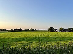
 The West Lancashire plain near Burscough | |
 Shown within the ceremonial county of Lancashire | |
| Sovereign state | United Kingdom |
| Constituent country | England |
| Region | North West England |
| Ceremonial county | Lancashire |
| Admin. HQ | Ormskirk |
| Government | |
| • Type | West Lancashire Borough Council |
| • Leadership | Leader and Cabinet |
| • MPs: |
|
| Area | |
• Total | 134 sq mi (347 km2) |
| • Rank | 102nd |
| Population (2022) | |
• Total | 119,367 |
| • Rank | Ranked 202nd |
| • Density | 890/sq mi (340/km2) |
| Ethnicity (2021) | |
| • Ethnic groups | |
| Religion (2021) | |
| • Religion | List
|
| Time zone | UTC+0 (Greenwich Mean Time) |
| • Summer (DST) | UTC+1 (British Summer Time) |
| Postcode | |
| ONS code |
|
West Lancashire is a local government district with borough status in Lancashire, England. The council is based in Ormskirk, and the largest town is Skelmersdale. The district borders Fylde to the north, over the Ribble Estuary; South Ribble, Chorley, and Wigan to the east; St Helens and Knowsley to the south; and Sefton to the south and west.
The borough has a population of 117,400 and an area of 133.8 square miles (347 km2).[2] It is primarily rural, and the most populous settlements after Ormskirk and Skelmersdale are Burscough (9,935), Up Holland (7,578), and Tarleton (5,959).[3] The borough council is based in Ormskirk, and there are twenty-one civil parishes.
The west of the borough contains much of the southern part of the Lancashire Plain, a low-lying region of mossland. A large lake called Martin Mere occupied much of the area until it was drained for agriculture. The northern border of the borough is the Ribble Estuary, and both it and the remnant of Martin Mere are Ramsar sites.[4] In the east the land rises to Harrock Hill, Parbold Hill, and Ashurst Hill; the River Douglas flows west through the valley between the last two, then turns north and forms the borough boundary.
- ^ a b UK Census (2021). "2021 Census Area Profile – West Lancashire Local Authority (E07000127)". Nomis. Office for National Statistics. Retrieved 5 January 2024.
- ^ "How life has changed in West Lancashire: Census 2021". Office for National Statistics. Retrieved 18 December 2023.
- ^ Parish populations.
- ^ "NCA Profile: 32 Lancashire and Amounderness Plain - NE512". Natural England. Retrieved 18 December 2023.