Back ريكسهام Arabic ريكسام ARZ Wrecsam AST ورکسام AZB Рексем Bashkir Рексъм (град) Bulgarian Wrecsam Breton Wrexham (kapital sa munisipyo) CEB Wrexham Czech Wrecsam Welsh
Wrexham
| |
|---|---|
| City | |
From top, left to right: Wrexham skyline, Hope Street, Erddig Hall and St Giles' Church. | |
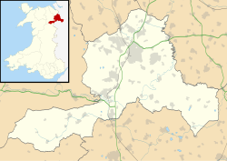
Location within Wrexham | |
| Population | 44,785 (Built up area, 2021)[1] |
| OS grid reference | SJ335505 |
| • Cardiff | 108[2] mi (174 km) S |
| Principal area | |
| Preserved county | |
| Country | Wales |
| Sovereign state | United Kingdom |
| Post town | WREXHAM |
| Postcode district | LL11—14 |
| Dialling code | 01978 |
| Police | North Wales |
| Fire | North Wales |
| Ambulance | Welsh |
| UK Parliament | |
| Senedd Cymru – Welsh Parliament | |
| Website | www |
Wrexham (/ˈrɛksəm/ REK-səm; Welsh: Wrecsam [ˈrɛksam]) is a city[a] in the north-east of Wales. It lies between the Welsh mountains and the lower Dee Valley, near the border with Cheshire in England. Historically in the county of Denbighshire, it became part of the new county of Clwyd in 1974. It has been the principal settlement and administrative centre of Wrexham County Borough since 1996. At the 2021 census, the built up area had a population of 44,785, and the wider county borough, which also includes surrounding villages and rural areas, had a population of 135,117. Wrexham was awarded city status in 2022.
Wrexham was likely founded before the 11th century and developed in the Middle Ages as a regional centre for trade and administration. Wrexham has historically been one of the primary settlements of Wales, and was the largest settlement in Wales for a time in the 17th century. In the Industrial Revolution from the 18th century onwards, Wrexham and surrounding area was a major centre of coal and lead mining. Other significant industries included the production of iron, steel and leather, and brewing.
Wrexham serves north Wales and the Welsh borderlands as a centre for manufacturing, retail, education and administration. The city is noted for Wrexham A.F.C. (one of the oldest professional football teams in the world); the nationally significant industrial heritage of the Clywedog Valley; the National Trust Property of Erddig; and the fine Tudor church of St Giles, which towers over the historic Wrexham city centre.
- ^ "Towns and cities, characteristics of built-up areas, England and Wales: Census 2021". Census 2021. Office for National Statistics. Retrieved 8 August 2023.
- ^ "Distance between Postcodes Calculator". www.postcode.org.uk. Archived from the original on 11 August 2022. Retrieved 4 May 2022.
Cite error: There are <ref group=lower-alpha> tags or {{efn}} templates on this page, but the references will not show without a {{reflist|group=lower-alpha}} template or {{notelist}} template (see the help page).


