Back Кирибати Abkhazian Kiribati ACE Kiribati Afrikaans Kiribati ALS ኪሪባስ Amharic Kiribati AMI Kiribati AN Kiribas ANG कीरीबाती ANP كيريباتي Arabic
Republic of Kiribati Ribaberiki Kiribati | |
|---|---|
| Motto: "Te Mauri, Te Raoi ao Te Tabomoa" "Health, Peace and Prosperity" | |
| Anthem: Teirake Kaini Kiribati Stand up, Kiribati | |
 | |
| Capital and largest city | South Tarawa[1] 1°28′N 173°2′E / 1.467°N 173.033°E |
| Official languages | English |
| Recognised national languages | Gilbertese |
| Ethnic groups (2000) | 98.8% Micronesian 1.2% others |
| Demonym(s) | I-Kiribati |
| Government | Parliamentary republic |
| Taneti Mamau[2] | |
| Teuea Toatu | |
| Legislature | House of Assembly |
| Independence | |
• from the United Kingdom | 12 July 1979 |
| Area | |
• Total | 811 km2 (313 sq mi) (186th) |
| Population | |
• 2010 estimate | 103,500 (197th) |
• 2015 census | 110,136 |
• Density | 136/km2 (352.2/sq mi) (73rd) |
| GDP (PPP) | 2011 estimate |
• Total | $599 million[3] |
• Per capita | $5,721[3] |
| GDP (nominal) | 2011 estimate |
• Total | $167 million[3] |
• Per capita | $1,592[3] |
| HDI (2013) | medium · 121st |
| Currency | Kiribati dollar Australian dollar (AUD) |
| Time zone | UTC+12, +13, +14 (GMT+12 to +14) |
| Driving side | left |
| Calling code | +686 |
| ISO 3166 code | KI |
| Internet TLD | .ki |
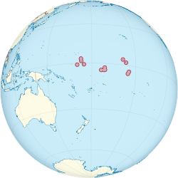
Kiribati (/ˌkɪrɪˈbæs, -ˈbɑːti/) is an island country in the Pacific Ocean. It has 33 atolls, groups of tiny islands. The country is near the equator. Part of it is in Micronesia and part is in Polynesia. Its capital is South Tarawa, on the Tarawa atoll.
Kiribati used to be called the Gilbert Islands. The name "Kiribati" comes from the way local people say "Gilberts".[4] In 1892, the Gilbert Islands became a British protectorate with the Ellice Islands (now known as Tuvalu), together called Gilbert and Ellice Islands. Kiribati became an independent republic in 1979.
Tourism is an important industry. Most food comes from farming and fishing. People grow breadfruit, papayas, coconuts, sweet potatoes, and vegetables. The soil is not very good, but people use a special way of composting to make it better.[5]
The official languages of Kiribati are English and Gilbertese.
- ↑ "Kiribati government website". Government of Kiribati. Archived from the original on 26 June 2010. Retrieved 24 June 2010.
- ↑ "Taneti Mamau declared new Kiribati President". Retrieved 29 March 2016.
- ↑ 3.0 3.1 3.2 3.3 "Kiribati". International Monetary Fund. Retrieved 19 April 2012.
- ↑ Petersen, Glenn (2009). Traditional Micronesian societies : adaptation, integration, and political organization. Honolulu: University of Hawai'i Press. ISBN 978-1-4416-1992-1. OCLC 436752926.
- ↑ "Find Agriculture expertise in Kiribati". Commonwealth of Nations. Archived from the original on 2 May 2023. Retrieved 13 February 2023.

