Back Автомагистрала А3 (Хърватия) Bulgarian Autoput A3 (Hrvatska) BS Dálnice A3 (Chorvatsko) Czech Autocesta A3 German Αυτοκινητόδρομος Α3 (Κροατία) Greek Kroata aŭtovojo A3 Esperanto Autoroute A3 (Croatie) French Autocesta A3 Croatian A3-as autópálya (Horvátország) Hungarian Autocesta A3 Italian
| A3 motorway | |
|---|---|
| Autocesta A3 | |
| Autocesta Bregana - Lipovac | |
 | |
| Route information | |
| Part of | |
| Length | 306.5 km (190.5 mi) |
| Major junctions | |
| From | |
| To | |
| Location | |
| Country | Croatia |
| Counties | City of Zagreb, Zagreb County, Sisak-Moslavina, Brod-Posavina, Vukovar-Srijem |
| Major cities | Zagreb, Kutina, Nova Gradiška, Slavonski Brod, Županja |
| Highway system | |
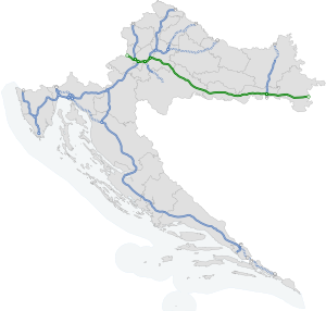
The A3 motorway (Croatian: Autocesta A3) is a major motorway in Croatia spanning 306.5 kilometres (190.5 mi). The motorway connects Zagreb, the nation's capital, to the Slavonia region and a number of cities along the Sava River. It represents a major east–west transportation corridor in Croatia and a significant part of the Pan-European Corridor X, serving as a transit route between the European Union states and the Balkans. Apart from Zagreb, where the A3 motorway comprises a considerable part of the Zagreb bypass, the motorway runs near a number of significant Croatian cities.[1]

The motorway consists of two traffic lanes and an emergency lane in each driving direction, separated by a central reservation. All intersections of the A3 motorway are grade separated, and the motorway comprises several large stack and cloverleaf interchanges at junctions with four other motorways in Croatia: A1, A2, A4 and A5. There is a cloverleaf interchange is on the A3 route, where the A11 motorway is scheduled to branch off. The route comprises a large number of bridges and culverts, but has no tunnels because it runs through plains. The Sava River Bridge is the most significant structure on the A3. Currently, there are 21 exits and 18 rest areas operating along the route.[2] A large part of the motorway is tolled using a ticket system; one section uses an open toll collection system. The Zagreb bypass sections are not tolled. The toll is charged according to vehicle classification in Croatia.[3] The A3 motorway is operated by Hrvatske autoceste.[4][5]
Construction of the six-lane motorway began in 1977, initially as the Zagreb bypass, then continued in the 1980s as an expansion of the existing two-lane road between Zagreb and Belgrade. The construction was suspended in the first part of the 1990s, due to the Croatian War of Independence, and resumed in 1996. Construction of the entire route was completed in 2006; further development entails new exits, new rest areas and the reconstruction of the existing motorway.[6] The construction cost of the A3 motorway is estimated at 7 billion Croatian kuna (approximately 958.9 million euro).[7]
- ^ "Odluka o označavanju autocesta" [Decision on motorway markings]. Narodne novine (in Croatian). January 5, 2022. Retrieved February 18, 2023.
- ^ Croatian Motorways. Hrvatske autoceste. 2007. pp. 255–281. ISBN 978-953-7491-09-3. Archived from the original (PDF) on 2011-02-18. Retrieved September 5, 2010.
- ^ "Toll payment conditions". Hrvatske autoceste. Archived from the original on 2011-07-18. Retrieved July 29, 2011.
- ^ "Zakon o javnim cestama" [Public Roads Act]. Narodne Novine (in Croatian). December 14, 2004. Retrieved September 6, 2010.
- ^ "Overview of motorways and semi-motorways". HUKA. Archived from the original on July 15, 2011. Retrieved September 8, 2010.
- ^ Cite error: The named reference
Građevinar-A3izgradnjawas invoked but never defined (see the help page). - ^ "U prometu dionica Županja–Lipovac autoceste A3" [Županja–Lipovac section of the A3 motorway opens for traffic]. Poslovni dnevnik (in Croatian). June 30, 2006. Archived from the original on September 30, 2011. Retrieved October 2, 2010.
