Back مقاطعة أسومبتيون (لويزيانا) Arabic Assumption Parish, Louisiana BAR অ্যসামশন পারিশ, লুইসিয়ানা BPY Assumption Gông (Louisiana) CDO Ассампшен (кӀошт, Луизиана) CE Assumption Parish CEB Assumption Parish, Louisiana Welsh Assumption Parish German Paroĥo Assumption/Assomption Esperanto Parroquia de Assumption Spanish
Assumption Parish | |
|---|---|
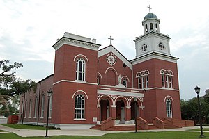
 St. Anne Catholic Church in Napoleonville | |
 Location within the U.S. state of Louisiana | |
 Louisiana's location within the U.S. | |
| Coordinates: 29°54′N 91°04′W / 29.9°N 91.06°W | |
| Country | |
| State | |
| Founded | 1807 |
| Named for | Assumption Roman Catholic Church |
| Seat | Napoleonville |
| Largest community | Pierre Part |
| Area | |
| • Total | 365 sq mi (950 km2) |
| • Land | 339 sq mi (880 km2) |
| • Water | 26 sq mi (70 km2) 7.1% |
| Population (2020) | |
| • Total | 21,039 |
| • Density | 58/sq mi (22/km2) |
| Time zone | UTC−6 (Central) |
| • Summer (DST) | UTC−5 (CDT) |
| Congressional districts | 2nd, 6th |
| Website | www |
Assumption Parish (French: Paroisse de l'Assomption, Spanish: Parroquia de la Asunción) is a parish located in the U.S. state of Louisiana. As of the 2020 census, the population was 21,039.[1] Its parish seat is Napoleonville.[2] Assumption Parish was established in 1807, as one of the original parishes of the Territory of Orleans.[3]
Assumption Parish is one of the twenty-two Acadiana parishes. Its major product is sugar cane. In proportion to its area, Assumption Parish produces the most sugar of any parish of Louisiana.
- ^ "Census - Geography Profile: Assumption Parish, Louisiana". United States Census Bureau. Retrieved January 21, 2023.
- ^ "Find a County". National Association of Counties. Archived from the original on May 31, 2011. Retrieved June 7, 2011.
- ^ "Assumption Parish". Center for Cultural and Eco-Tourism. Retrieved September 5, 2014.