Back مقاطعة كرو وينغ (مينيسوتا) Arabic Crow Wing County, Minnesota BAR Кроу Уинг (окръг, Минесота) Bulgarian ক্র ৱিং কাউন্টি, মিনেসোটা BPY Crow Wing Gông (Minnesota) CDO Crow Wing County CEB Crow Wing County, Minnesota Welsh Crow Wing County Danish Crow Wing County German Condado de Crow Wing Spanish
Crow Wing County | |
|---|---|
 | |
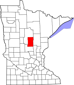
 Location within the U.S. state of Minnesota | |
 Minnesota's location within the U.S. | |
| Coordinates: 46°29′N 94°04′W / 46.49°N 94.07°W | |
| Country | |
| State | |
| Founded | May 23, 1857 (created) March 3, 1870 (organized) |
| Named for | Crow Wing River |
| Seat | Brainerd |
| Largest city | Brainerd |
| Area | |
| • Total | 1,157 sq mi (3,000 km2) |
| • Land | 999 sq mi (2,590 km2) |
| • Water | 157 sq mi (410 km2) 14% |
| Population (2020) | |
| • Total | 66,123 |
| • Estimate (2023) | 68,304 |
| • Density | 66.2/sq mi (25.6/km2) |
| Time zone | UTC−6 (Central) |
| • Summer (DST) | UTC−5 (CDT) |
| Congressional district | 8th |
| Website | crowwing |
Crow Wing County is a county in the East Central part of the U.S. state of Minnesota. As of the 2020 census, the population was 66,123.[1] Its county seat is Brainerd.[2] The county was formed in 1857, and was organized in 1870.[3]
Crow Wing County is included in the Brainerd, MN Micropolitan Statistical Area.
- ^ "State & County QuickFacts". United States Census Bureau. Retrieved April 13, 2023.
- ^ "Find a County". National Association of Counties. Archived from the original on May 31, 2011. Retrieved June 7, 2011.
- ^ "Minnesota Place Names". Minnesota Historical Society. Archived from the original on October 27, 2014. Retrieved March 17, 2014.