| Eleven Point River | |
|---|---|
 Eleven Point River, May 2018 | |
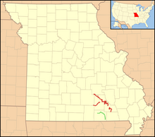
 Location of the Eleven Point Wild and Scenic River shown in green; nearby Ozark National Scenic Riverways in red | |
| Location | |
| Country | United States |
| State | Missouri, Arkansas |
| Region | Ozark Plateau, Mississippi Alluvial Plain |
| Cities | Willow Springs, Thomasville |
| Physical characteristics | |
| Source | |
| • location | Willow Springs, Howell County, Ozark Plateau, Missouri |
| Mouth | Spring River |
• location | Black Rock, Arkansas, Randolph County, Mississippi Alluvial Plain, Arkansas |
| Discharge | |
| • location | Ravenden Springs, Arkansas |
| • average | 1,171 cu/ft. per sec.[1] |
| Basin features | |
| Tributaries | |
| • left | Spring Creek, Hurricane Creek |
| • right | Middle Creek, Greer Spring, Frederick Creek, Blue Spring |
| Type | Scenic |
| Designated | October 2, 1968 |
The Eleven Point River is a 138-mile-long (222 km)[2] river in southern Missouri and northern Arkansas, United States.
- ^ USGS data
- ^ U.S. Geological Survey. National Hydrography Dataset high-resolution flowline data. The National Map Archived 2012-03-29 at the Wayback Machine, accessed March 9, 2011
