Back Gloppen BAR গ্লোপ্পেন BPY Gloppen Catalan Gloppen (munisipyo) CEB Gloppen Danish Gloppen German Gloppen Esperanto Gloppen Spanish Gloppen Basque Gloppen Finnish
Gloppen Municipality
Gloppen kommune | |
|---|---|
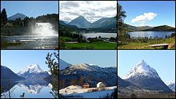
 Views of Gloppen | |
|
| |
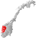
 Vestland within Norway | |
 Gloppen within Vestland | |
| Coordinates: 61°44′38″N 06°10′14″E / 61.74389°N 6.17056°E | |
| Country | Norway |
| County | Vestland |
| District | Nordfjord |
| Established | 1 Jan 1838 |
| • Created as | Formannskapsdistrikt |
| Administrative centre | Sandane |
| Government | |
| • Mayor (2023) | Arnar Kvernevik (Ap) |
| Area | |
| • Total | 1,030.52 km2 (397.89 sq mi) |
| • Land | 962.65 km2 (371.68 sq mi) |
| • Water | 67.88 km2 (26.21 sq mi) 6.6% |
| • Rank | #112 in Norway |
| Population (2023) | |
| • Total | 5,892 |
| • Rank | #162 in Norway |
| • Density | 6.1/km2 (16/sq mi) |
| • Change (10 years) | |
| Demonym | Gloppar[1] |
| Official language | |
| • Norwegian form | Nynorsk |
| Time zone | UTC+01:00 (CET) |
| • Summer (DST) | UTC+02:00 (CEST) |
| ISO 3166 code | NO-4650[3] |
| Website | Official website |
Gloppen is a municipality in the county of Vestland, Norway. It is located in the traditional district of Nordfjord. Gloppen is generally subdivided into three areas: Hyen in the west, Gloppen in the center, and Breim in the east.
Each of the areas have their own main service centres. Sandane, the administrative centre of the municipality, is the largest with about 2,500 inhabitants. Sandane, Vereide, and Sørstranda are centered on the Gloppefjorden in Gloppen in the central part of the municipality. The villages of Byrkjelo, Re, Kandal, and Egge are centered on the lake Breimsvatnet in the Breim area in the east. The villages of Straume, Eimhjellen, and Solheim are located around the Hyefjorden in Hyen in the west. The whole municipality sits on the southern side of the large Nordfjorden.
The European route E39 highway runs through the municipality before crossing the Nordfjorden on a car ferry. The Sandane Airport, Anda is located along the E39 highway, just north of Vereide.
The 1,031-square-kilometre (398 sq mi) municipality is the 112th largest by area out of the 356 municipalities in Norway. Gloppen is the 162nd most populous municipality in Norway with a population of 5,892. The municipality's population density is 6.1 inhabitants per square kilometre (16/sq mi) and its population has increased by 3.8% over the previous 10-year period.[4][5]
- ^ "Navn på steder og personer: Innbyggjarnamn" (in Norwegian). Språkrådet.
- ^ "Forskrift om målvedtak i kommunar og fylkeskommunar" (in Norwegian). Lovdata.no.
- ^ Bolstad, Erik; Thorsnæs, Geir, eds. (26 January 2023). "Kommunenummer". Store norske leksikon (in Norwegian). Kunnskapsforlaget.
- ^ Statistisk sentralbyrå. "Table: 06913: Population 1 January and population changes during the calendar year (M)" (in Norwegian).
- ^ Statistisk sentralbyrå. "09280: Area of land and fresh water (km²) (M)" (in Norwegian).

