Back منطقة جوراخبور Arabic جوراخبور ARZ गोरखपुर जिला Bihari গোরক্ষপুর জেলা Bengali/Bangla Districte de Gorakhpur Catalan Gorakhpur (distrito) CEB Gorakhpur (distrikt) Danish Gorakhpur (Distrikt) German Distrito de Gorakhpur Spanish Gorakhpur barrutia Basque
Gorakhpur district | |
|---|---|
 | |
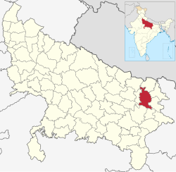
 Location of Gorakhpur district in Uttar Pradesh | |
| Country | |
| State | Uttar Pradesh |
| Division | Gorakhpur |
| Headquarters | Gorakhpur |
| Tehsils | 7 |
| Government | |
| • Lok Sabha constituencies | Gorakhpur, Bansgaon |
| • Commissioner | Jayant Narlikar IAS[1] |
| • D.M | Vijay Kiran Anand IAS[2] |
| • SSP | Dinesh Kumar P. IPS [3] |
| Area | |
| • Total | 3,448 km2 (1,331 sq mi) |
| Population (2011 Census)[5] | |
| • Total | 4,440,895 |
| • Density | 1,300/km2 (3,300/sq mi) |
| • Urban | 836,129 |
| Demographics | |
| • Literacy | 77.83%. |
| • Sex ratio | 950 |
| Time zone | UTC+05:30 (IST) |
| Vehicle registration | UP-53 |
| Major highways | NH 28, NH 233B, NH 29 |
| Languages | Hindi, Bhojpuri, Urdu |
| Website | gorakhpur |
Gorakhpur district is one of the 75 districts of Uttar Pradesh state in northern India. This district is a part of the Gorakhpur division. The city of Gorakhpur, or Gorakhpur is the administrative headquarters of this district and Gorakhpur division. It borders Sant Kabir Nagar district to the west, Kushinagar and Deoria districts to the east, and Maharajganj and Azamgarh districts to the north and south.
- ^ "जयंत नार्लिकर बने गोरखपुर कमिश्नर". IndiaTimes. Retrieved 28 March 2019.
- ^ "DM Details– Gorakhpur District". Retrieved 26 September 2021.
- ^ "Indian Bureaucracy". Retrieved 31 March 2021.
- ^ "Gorakhpur". Retrieved 26 October 2018.
- ^ Cite error: The named reference
districtcensuswas invoked but never defined (see the help page).