Back خليج هانغتشو Arabic Ханчжаўвань Byelorussian Ханджоуван Bulgarian হাংচৌ উপসাগর Bengali/Bangla Chang-čou (zátoka) Czech Hangzhoubugten Danish Hangzhou-Bucht German Bahía de Hangzhou Spanish Hangzhou badia Basque Baie de Hangzhou French

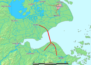
Hangzhou Bay[a] is a funnel-shaped inlet of the East China Sea, bordered by the province of Zhejiang and the municipality of Shanghai, which lies north of the Bay. The Bay extends from the East China Sea to its head at the city of Hangzhou, from which its name is derived.
At Hangzhou, the Qiantang River flows into this Bay, providing freshwater from the West while seawater comes in from the East. Thus, Hangzhou Bay, especially its western end, is sometimes called in the scientific literature as the Qiantang River Estuary.[1]
At the southeast end of Hangzhou Bay, off Ningbo, are many small islands that are collectively called the Zhoushan Islands. This archipelago of islands is urbanized with the administrative status of a prefecture-level city in Zhejiang Province.
At less than 15 meters in depth, the entire Bay is relatively shallow. Consequently, the main port in the Bay area is the one in Ningbo and Zhoushan, at the southeast end of the Bay on the coast of East China Sea.
Cite error: There are <ref group=lower-alpha> tags or {{efn}} templates on this page, but the references will not show without a {{reflist|group=lower-alpha}} template or {{notelist}} template (see the help page).
- ^ Li, Ying; Pan, Dong-Zi; Chanson, Hubert; Pan, Cun-Hong (July 2019). "Real-time characteristics of tidal bore propagation in the Qiantang River Estuary, China, recorded by marine radar" (PDF). Continental Shelf Research. 180. Elsevier: 48–58. Bibcode:2019CSR...180...48L. doi:10.1016/j.csr.2019.04.012. S2CID 155917795.