Back Karibib Afrikaans كاريبيب ARZ Karibib (lungsod) CEB Karibib German Distrito electoral de Karibib Spanish Karibib Finnish Karibib French Karibib Italian 카리비브 Korean Karibib Dutch
Karibib
Otjiherero: Otjandjomboimwe | |
|---|---|
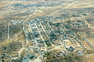
 Karibib aerial view 2017 | |
| Coordinates: 21°56′17″S 15°51′16″E / 21.93806°S 15.85444°E | |
| Country | |
| Region | Erongo Region |
| Constituency | Karibib Constituency |
| Founded | 1900 |
| Government | |
| • Mayor | Dawid Iipinge[1] |
| Population (2011)[2] | |
| • Total | 5,132 |
| Time zone | UTC+2 (South African Standard Time) |
| Climate | BWh |

Karibib (Otjiherero: Otjandjomboimwe) is a town in the Erongo Region of western Namibia. It has 3,800 inhabitants and owns 97 square kilometres (37 sq mi) of town land.[3] Karibib is the district capital of the Karibib electoral constituency. It is situated on the Khan River, halfway between Windhoek and Swakopmund on the B2 (Trans-Kalahari Highway), the main road between Walvis Bay and Johannesburg. The town is known for its aragonite marble quarries and the Navachab Gold Mine.
- ^ "Four towns re-elect mayors". The Namibian. NAMPA. 9 December 2013. Archived from the original on 11 December 2013. Retrieved 9 December 2013.
- ^ "Table 4.2.2 Urban population by Census years (2001 and 2011)" (PDF). Namibia 2011 – Population and Housing Census Main Report. Namibia Statistics Agency. p. 39. Retrieved 24 August 2016.
- ^ "ELECTIONS 2010: Erongo regional profile". New Era. 16 November 2010. Archived from the original on 6 September 2012.
