Back مقاطعة كوتشيتشينغ (مينيسوتا) Arabic Koochiching County, Minnesota BAR Кучичинг (окръг, Минесота) Bulgarian কোচিচিং কাউন্টি, মিনেসোটা BPY Koochiching Gông (Minnesota) CDO Koochiching County CEB Koochiching County, Minnesota Welsh Koochiching County Danish Koochiching County German Condado de Koochiching Spanish
Koochiching County | |
|---|---|
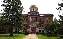
 Koochiching County Courthouse | |
 Location within the U.S. state of Minnesota | |
 Minnesota's location within the U.S. | |
| Coordinates: 48°16′N 93°46′W / 48.26°N 93.77°W | |
| Country | |
| State | |
| Founded | December 19, 1906[1] |
| Named for | Ojibway words for neighbor lake, river |
| Seat | International Falls |
| Largest city | International Falls |
| Area | |
| • Total | 3,154 sq mi (8,170 km2) |
| • Land | 3,104 sq mi (8,040 km2) |
| • Water | 50 sq mi (100 km2) 1.6% |
| Population (2020) | |
| • Total | 12,062 |
| • Estimate (2023) | 11,751 |
| • Density | 3.9/sq mi (1.5/km2) |
| Time zone | UTC−6 (Central) |
| • Summer (DST) | UTC−5 (CDT) |
| Congressional district | 8th |
| Website | www |
Koochiching County (/ˈkuːtʃɪtʃɪŋ/ KOOCH-itch-ing) is a county in the U.S. state of Minnesota. As of the 2020 census, the population was 12,062.[2] Its county seat is International Falls.[3] A portion of the Bois Forte Indian Reservation is in the county. A small part of Voyageurs National Park extends into its boundary, with Lake of the Woods County to its northwest.
- ^ "Minnesota Place Names". Minnesota Historical Society. Archived from the original on June 20, 2012. Retrieved March 18, 2014.
- ^ "State & County QuickFacts". United States Census Bureau. Retrieved April 23, 2023.
- ^ "Find a County". National Association of Counties. Archived from the original on May 31, 2011. Retrieved June 7, 2011.