Back جبل إيدا Arabic جبل ايدا ARZ Menez Ida (Kreta) Breton Psiloritis Catalan Óros Ídi CEB Psiloritis Czech Idabjerget Danish Psiloritis German Ψηλορείτης Greek Monte Ida (Creta) Spanish
| Mount Ida | |
|---|---|
| Psiloritis (summit Ida) | |
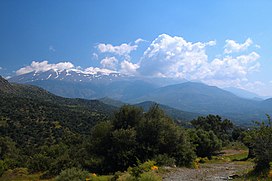
 View of Psiloritis mountains from the west | |
| Highest point | |
| Elevation | 2,456 m (8,058 ft)[1] |
| Prominence | 2,456 m (8,058 ft)[2] |
| Isolation | 439.94 km (273.37 mi) |
| Listing | Ultra |
| Coordinates | 35°13′36″N 24°46′21″E / 35.22667°N 24.77250°E[2] |
| Geography | |
| Location | Crete, Greece |
Mount Ida (Greek: Ἴδα),[3][4] known variously as Idha, Ídhi, Idi, and Ita (the massif including the mountain is called Psiloritis, Greek: Ψηλορείτης),[5] is the highest mountain on the island of Crete, with an elevation of 2,456 metres (8,058 ft). It has the highest topographic prominence of any mountain in Greece.[2][6] A natural park which includes Mount Ida is a member of UNESCO's Global Geoparks Network.
Located in the Rethymno regional unit, Ida was sacred to the Titaness Rhea in Greek mythology. On its slopes lies one of the caves, Idaion Antron, the Idaean Cave, in which, according to legend, the god Zeus was born. Other legends, however, place his birthplace in Psychro Cave on the Lasithi Plateau.
An archaeobotanical study was conducted that looks at the different plant bases in Minoan villas during the Neo-palatial time period in Crete. There was a rich range of food plants that were found to contain essential nutrients such as carbohydrates, protein and sources of vitamins.[7] The study took place on Mount Ida, at the Minoan villa of Zominthos.
- ^ "Mount Ida, Greece". Peakbagger.com. Retrieved 2 May 2015.
- ^ a b c "Europe Ultra-Prominences". Peakbagger.org. Retrieved 2 May 2015.
- ^ Verse 332 of the act B, of the bucolic drama Πανώρια by the 16th century Cretan writer Γεωργίος Χορτάτσης: «Ἐγὼ δὲ θὲ νὰ παντρευτῶ καὶ βρὲ ἄλλη κορασίδα, ἀπ’ ὄμορφες ἀρίφνητες ἁπού ‘ν’ ἐπὰ εις τὴν Ἴδα˙» (The tomonym is mentioned several times in this work.)
- ^ Summit Ida in the center of the map, by Marco Boschini, 17th century Venice. Item (GE C-8841) National Library of France.
- ^ Psiloritis in the center of the map, by Abraham Ortelius, 1598 Antwerp, from Archipelagi Insularum Aliquot Descrip.
- ^ Topo25 Hiking Map of Mt IDHA (2006 edition)
- ^ Livarda, Alexandra; Kotzamani, Georgia (2020-09-16). "Plant resources and subsistence in the Late Minoan mountain 'villa' at Zominthos, Crete". Archaeological and Anthropological Sciences. 12 (10): 237. doi:10.1007/s12520-020-01203-1. ISSN 1866-9565. S2CID 221718769.
