Back Point Loma German Point Loma Spanish Point Loma French Point Loma Hungarian Point Loma, San Diego SIMPLE Point Loma Swedish
Point Loma | |
|---|---|
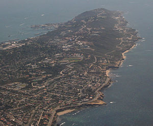
 Aerial view of Point Loma, facing south, March 2007 | |
 The Point Loma peninsula at left | |
| Coordinates: 32°40′12″N 117°14′31″W / 32.67000°N 117.24194°W | |
| Country | |
| State | |
| County | |
| City | |
| ZIP Code | 92106 and 92107 |
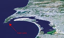
Point Loma (Spanish: Punta de la Loma, meaning "Hill Point"; Kumeyaay: Amat Kunyily, meaning "Black Earth")[1] is a seaside community within the city of San Diego, California, United States. Geographically it is a hilly peninsula that is bordered on the west and south by the Pacific Ocean, the east by the San Diego Bay and Old Town, and the north by the San Diego River. Together with the Silver Strand / Coronado peninsula, the Point Loma peninsula defines San Diego Bay and separates it from the Pacific Ocean. The term "Point Loma" is used to describe both the neighborhood and the peninsula.
Point Loma has an estimated population of 47,981 (including Ocean Beach), according to the 2010 Census.[2][3] The Peninsula Planning Area, which includes most of Point Loma, comprises approximately 4,400 acres (1,800 ha).[4]
Point Loma is historically important as the landing place of the first European expedition to come ashore in present-day California. Point Loma houses two major military bases, a national cemetery, a national monument, and a university, in addition to residential and commercial areas.
- ^ Cite error: The named reference
Kumeyaay.comwas invoked but never defined (see the help page). - ^ "2010 Census Population for ZIP Code 92107". Zip-codes.com. Retrieved January 5, 2013.
- ^ "2010 Census Population for ZIP Code 92106". Zip-codes.com. Retrieved January 5, 2013.
- ^ "Peninsula Community Plan" (PDF). City of San Diego. Retrieved January 30, 2013.