Back نهر شاردا Arabic شاردا چایی AZB शारदा नदी Bihari Riu Sarda Catalan Кали (Гориганга юппи)) CV Mahakali (Fluss) German महाकाली नदी DTY Ŝarda Esperanto Sharda (rivière) French કાલી નદી (ઉત્તરાંચલ) Gujarati
| Sharda River Mahakali River | |
|---|---|
 Sharda River near Jauljibi in Uttarakhand | |
| Location | |
| Countries | India and Nepal |
| Region | Uttarakhand and Uttar Pradesh in India; Sudurpashchim Province in Nepal |
| Physical characteristics | |
| Source | |
| • location | Pithoragarh district, Uttarakhand |
| • coordinates | 30°14′32″N 81°01′19″E / 30.2421°N 81.0219°E |
| • elevation | 3,600 m (11,800 ft) |
| 2nd source | |
| • location | South of Lipu Lekh, India–Tibet border |
| • coordinates | 30°26′18″N 80°34′14″E / 30.4384°N 80.5706°E |
| • elevation | 5,553 m (18,219 ft) |
| Mouth | |
• location | Ghaghra River, Uttar Pradesh, India |
• coordinates | 27°38′27″N 81°17′26″E / 27.6408°N 81.2905°E |
• elevation | 115 m (377 ft) |
| Length | 350 km (220 mi) |
| Basin size | 14,871 km2 (5,742 sq mi) |
| Discharge | |
| • average |
|
| Basin features | |
| River system | Ganges |
| Tributaries | |
| • left | Chameliya, Ramgun in Nepal |
| • right | Kuthi, Dhauli, Gori, Sarju, Ladhiya rivers in Uttarakhand |
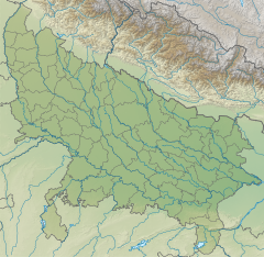
The Sharda River is the downstream of Kali River (or Mahakali River) that originates in the northern Uttarakhand state of India in the Great Himalayas on the eastern slopes of Nanda Devi massif,[1] at an elevation of 3,600 m (11,800 ft) in the Pithoragarh district. It then flows between the Nepal and India border.[2] Descending, it enters the Indo-Gangetic Plain at Brahmadev Mandi in Nepal, where it expands above the Sharda Barrage. From that point onward, it is known as the Sharda River. The river proceeds southeastward into India through northern Uttar Pradesh before merging with the Ghaghara River southwest of Bahraich, covering a distance of approximately 300 miles (480 km).[1][3]
It offers potential for hydroelectric power generation. The river is also proposed as source for one of the many projects in the Himalayan component of the Indian Rivers Inter-link project.[4]
- ^ a b "Sarda River | Map, India, & Facts | Britannica". Encyclopedia Britannica. Retrieved 9 May 2024.
- ^ Midha, N. & Mathur, P.K. (2014). "Channel characteristics and planform dynamics in the Indian Terai, Sharda River" (PDF). Environmental Management. 53 (1): 120–134. Bibcode:2014EnMan..53..120M. doi:10.1007/s00267-013-0196-4. PMID 24202283. S2CID 6159788.
- ^ Walton, H. G., ed. (1911). "Chapter I. General Features. River Basins". Almora: A Gazetteer. District Gazetteers of the United Provinces of Agra and Oudh. Vol. 35. Allahabad: Government Press, United Provinces. pp. 3–4.
- ^ "Kali river". www.euttaranchal.com. 14 December 2015. Retrieved 16 January 2022.


