Back نهر الترن Arabic نهر تارن ARZ تارن چایی AZB Тарн Bulgarian তার্ন নদী Bengali/Bangla Tarn (stêr) Breton Riu Tarn Catalan Tarn (suba sa Pransiya) CEB Tarn (řeka) Czech Afon Tarn Welsh
| Tarn | |
|---|---|
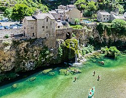
 The Tarn in Saint-Chély-du-Tarn, Gorges du Tarn Causses | |
 Path of the Tarn [1] | |
| Location | |
| Country | France |
| Physical characteristics | |
| Source | Mont Lozère |
| • location | Cévennes, France |
| • coordinates | 44°24′53″N 3°48′54″E / 44.41472°N 3.81500°E |
| • elevation | 1,550 m (5,090 ft) |
| Mouth | Garonne |
• location | Moissac, France |
• coordinates | 44°05′10″N 1°02′33″E / 44.086111°N 1.0425°E |
| Length | 380 km (240 mi) |
| Basin size | 15,700 km2 (6,100 sq mi) |
| Discharge | |
| • average | 140 m3/s (4,900 cu ft/s) |
| Basin features | |
| Progression | Garonne→ Gironde estuary→ Atlantic Ocean |
The Tarn (French pronunciation: [taʁn] ; Occitan: Tarn, Latin: Tarnis, possibly meaning 'rapid' or 'walled in') is a 380.2-kilometre (236.2 mi) long river in the administrative region of Occitania in southern France. It is a right tributary of the Garonne.[1]
The Tarn runs in a roughly westerly direction, from its source at an elevation of 1,550 m (5,090 ft) on Mont Lozère in the Cévennes mountains (part of the Massif Central), through the deep gorges and canyons of the Gorges du Tarn that cuts through the Causse du Larzac, to Moissac in Tarn-et-Garonne, where it joins the Garonne, 4 km (2.5 mi) downstream from the centre of town.
Its basin covers approximately 12,000 square kilometres (4,600 sq mi), and it has a mean flow of approximately 140 cubic metres per second (4,900 cu ft/s).
The Millau Viaduct spans the valley of the Tarn near Millau, and is now one of the area's most popular attractions.